North Table Mountain, Golden: Trails, the West Trailhead, and Parking
North Table Mountain is the flat-topped mesa on the north edge of Golden, and it packs more than 15 miles of trail onto one big grassy tabletop about 700 feet above town. From the West Trailhead on Highway 93 you climb a short, steep grade up onto the rim, then walk easy, nearly level miles with the Denver skyline on one side and the Front Range foothills on the other. It's open, it's fast to reach from the metro, and the views start almost the moment you top out.
Two things trip up first-timers: parking and water. The West Trailhead lot fills early on weekend mornings, and there's no water once you're on the mesa, which bakes in full sun with almost no shade. Sort those out and North Table is one of the best short-drive hikes on the Front Range. This guide covers how to get there, where to park at the West Trailhead, the loops worth your time, the climbing cliffs and their seasonal closures, and what to bring so the afternoon doesn't catch you out.
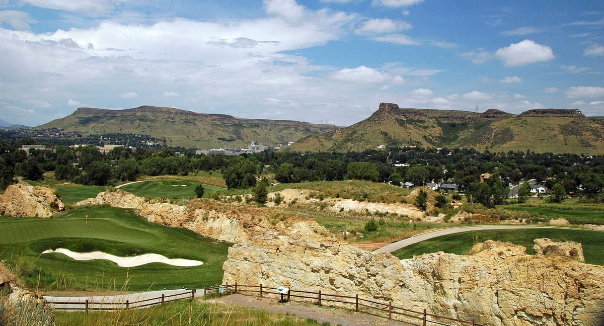
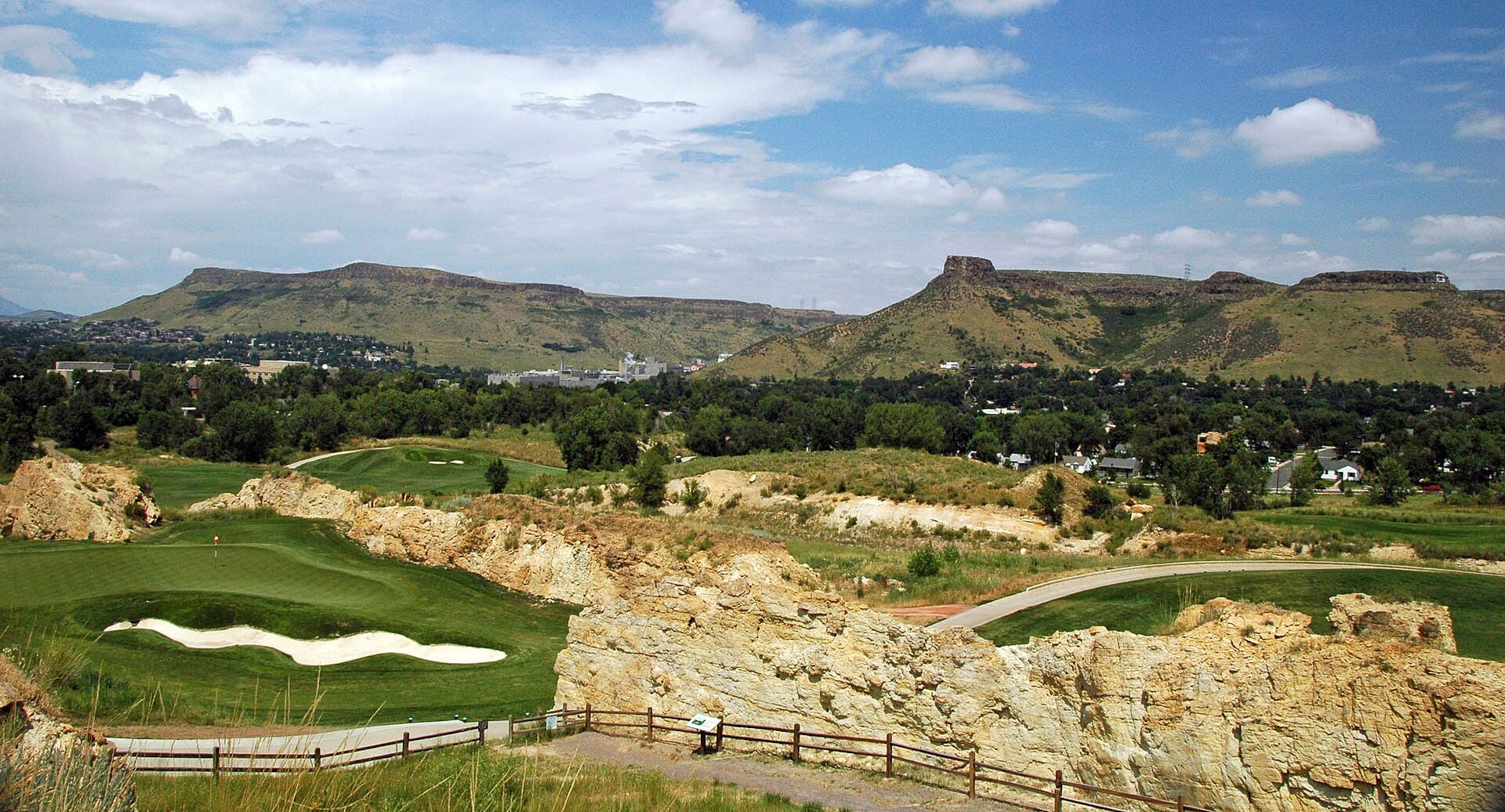
North Table Mountain (left) and South Table Mountain frame Golden. The dark caprock is ancient lava, which is why the rims break into cliffs.
Quick pick: First visit? Park at the North Table Mountain West Trailhead, climb the road grade up onto the rim, and link the North Table Loop for a roughly 7-mile lap around the mesa. Short on time or hiking with kids? Go up to the first overlook and back for a big view in under an hour.
Planning a Front Range day? Pair this with our best day hikes near Denver roundup, read up on Colorado trailhead parking before a summer weekend, and if you're new to hiking at altitude start with the Colorado hiking beginner's guide.
What You'll Learn
- What Makes North Table Mountain Worth the Climb
- Where Is North Table Mountain and How to Get There
- The North Table Mountain West Trailhead
- The Best Hikes on North Table Mountain
- The Golden Cliffs, Climbing, and Raptor Closures
- What to Bring: Heat, Sun, and No Shade
- Wildlife, Dogs, and Trail Rules
- Best Time to Hike North Table Mountain
- Make a Day of It in Golden
- Frequently Asked Questions
What Makes North Table Mountain Worth the Climb
Most Front Range foothill hikes are a steady grind up a canyon. North Table is different. You do the climbing in one short burst to gain the rim, and then the top opens into a broad, tilted meadow you can wander for hours on nearly flat trail. That combination, a quick lung-buster followed by miles of easy walking with 360-degree views, is what keeps locals coming back before work.
The mesa is a Jefferson County Open Space park covering roughly 1,900 acres of grassland and rock on the north side of Clear Creek. The top sits around 6,500 feet, a little over 700 feet above downtown Golden. What gives it the sharp, table-like edge is the caprock: a layer of ancient lava that hardened into dark basalt tens of millions of years ago and now protects the softer rock underneath. That same lava forms the Golden Cliffs along the southwest face, which you'll see from the highway and which draw rock climbers all season.
From the rim you get one of the better view sampler platters in the metro. Golden and the Coors brewery sit right below you, the downtown Denver skyline stacks up to the east, and the foothills roll west toward the Continental Divide. On a clear morning you can pick out Mount Blue Sky and the higher peaks behind the first ridge of the Front Range.
Where Is North Table Mountain and How to Get There
North Table Mountain sits just north of downtown Golden, about 25 to 30 minutes from downtown Denver. The fastest way from the metro is US-6 west through Clear Creek Canyon's mouth into Golden, or I-70 to the Golden exits and north through town. From Boulder, it's a straight shot south on Highway 93, which runs right past the two main trailheads.
The park has trailheads on three sides, and picking the right one matters because they access different parts of the mesa:
- West Trailhead, on Highway 93 a few minutes north of downtown Golden. This is the big paved lot and the most popular way up. It puts you at the base of the western climb.
- North Trailhead, farther north on Highway 93. A smaller lot that feeds the Cottonwood Canyon side and the quieter north end of the loop.
- East neighborhood access off Peery Parkway, tucked into the Golden neighborhoods below the southeast rim. Handy if you live nearby, tight on parking if you don't.
For a first visit, use the West Trailhead. It has the clearest signage, restrooms, and the most direct line to the classic loop. If it's a packed Saturday and the west lot is full, the North Trailhead is your backup.
The North Table Mountain West Trailhead
The North Table Mountain West Trailhead is the front door to the mesa, right on Highway 93 on the west side of the park. It's a paved lot with vault toilets, trailhead maps, and a wide, obvious path leading up. There's no drinking water here, so fill your bottles before you leave home.
Here's the honest truth about parking: the lot fills early. On summer and fall weekends, plan to arrive by 8 AM, earlier if the weather's perfect. By mid-morning on a Saturday you'll be circling or parking along the shoulder, and Highway 93 is a fast road where roadside parking is both tight and legally iffy. Weekday mornings are wide open, and even weekend evenings clear out as the day-hikers head home. The park is open dawn to dusk, so a golden-hour lap after work is one of the best-kept routines in Golden.
The climb starts right out of the lot. The path goes up a wide, steady grade along the western flank, gaining most of the day's elevation in the first mile or so. It's exposed and it'll get your heart going, especially at altitude if you're visiting from lower ground. Take it slow, and know that once you crest the rim the grade nearly disappears. A pair of trail running shoes with real grip handles the loose gravel on the way back down a lot more kindly than road sneakers.
If parking is the part that stresses you out, our guide to Colorado trailhead parking walks through timing, overflow strategy, and how the busiest Front Range lots behave through the seasons.
The Best Hikes on North Table Mountain
The trail network up top is a web of shared-use paths, so you can build a hike as short or as long as you want. These are the routes worth knowing.
The North Table Loop (about 7 miles). This is the signature hike, a full lap around the perimeter of the mesa. After the climb from the West Trailhead, the loop rolls along the rim with almost no elevation change, roughly 7 to 8 miles round trip depending on how you cut it, with most of the day's 700 to 1,000 feet of gain packed into the initial climb. Give it 3 to 4 hours at a relaxed pace with photo stops. Going clockwise puts the Denver views in front of you for the sunny stretch.
Out-and-back to the first overlook (about 2 to 3 miles). Short on time or bringing kids or first-time hikers? Just climb to the rim and walk out to the first big viewpoint over Golden, then turn around. You get most of the payoff for a fraction of the effort, and it's a great sunrise mission.
Mesa Top and the interior trails. Once you're up top, spur trails like the Mesa Top Trail cut across the tabletop instead of hugging the edge. These are the quiet miles, good for stitching together a custom loop or adding distance without adding much climbing.
Cottonwood Canyon from the North Trailhead. Starting on the north side gives you a different feel, climbing up through the Cottonwood Canyon drainage and connecting into the loop from the top end. It's the move when the West Trailhead is a zoo.
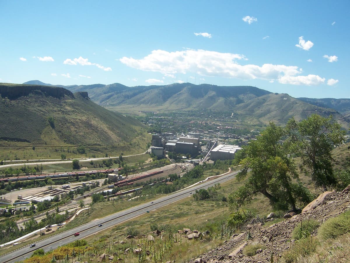
The reward for the climb: Golden, the brewery, and Clear Creek Canyon spread out below the rim, with the foothills climbing west toward the Divide.
Mountain bikers and trail runners share these trails, so keep right and expect faster traffic from behind on the flat sections. The paths are well signed at the junctions, but it's still worth a photo of the trailhead map on your phone before you start, since the interior can feel same-y once you're a couple miles in.
The Golden Cliffs, Climbing, and Raptor Closures
The dark band of rock along the southwest rim is the Golden Cliffs, and it's one of the more popular beginner-to-intermediate rock climbing areas near Denver. The basalt gives short, bolted routes on solid stone a few minutes' walk from the road, which is why you'll often see climbers working the wall below the Golden Cliffs Trail.
Here's the part hikers and climbers both need to know: parts of the cliffs close every year to protect nesting raptors. Prairie falcons and other birds of prey nest on the rock, and Jefferson County Open Space closes the affected climbing routes and some cliff-edge trails during nesting season, which typically runs from around February 1 through July 31. The exact closures shift year to year and by section, so check the Jeffco Open Space page or the posted signs at the trailhead before you count on a specific route or overlook being open. The main loop up top stays open; it's the cliff-edge routes that get roped off.
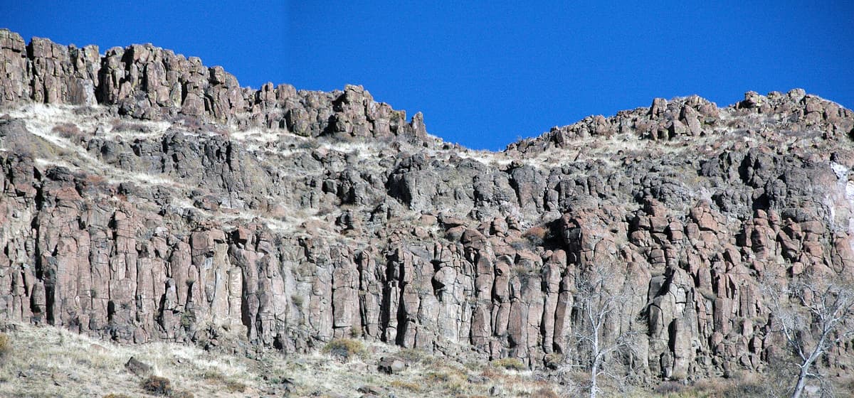
The basalt caprock along the rim breaks into blocky columns. This same rock forms the Golden Cliffs climbing area on the southwest face.
Even if you never rope up, the cliffs are worth walking out to see. The columns of hardened lava stacked along the edge are the clearest look you'll get at why the mesa has its shape.
What to Bring: Heat, Sun, and No Shade
If there's one thing to remember about North Table, it's that there is almost no shade. You're on an exposed grassland tabletop, and in July and August the top can run 15 to 20 degrees hotter than it feels in the parking lot. People underestimate this hike constantly because the map says "easy" once you're up top, then they run out of water two miles from the car.
Pack for sun and heat first:
- Water, more than you think. There's none on the mesa. Two liters per person in summer is a floor, not a ceiling. A hydration pack makes it easy to sip steadily instead of rationing.
- Sun protection. A wide-brim sun hat, sunglasses, and sport sunscreen reapplied halfway through. Colorado sun at 6,500 feet burns faster than the temperature suggests.
- Grippy shoes. The initial climb is loose and gravelly, and it's steeper on the way down than it felt going up.
- A wind layer. The top is open and it can be breezy and cool early, then hot by 10 AM. A light shell packs down to nothing.
For a broader packing rundown that carries over to any Front Range day hike, see our notes on what to wear hiking in changeable Colorado weather.
Wildlife, Dogs, and Trail Rules
North Table is prime foothills grassland, which means it's rattlesnake country from spring through early fall. They're not out to get you; they want the sun on a rock or the shade under it. Stay on trail, watch where you step and where you put your hands near rocks, and keep dogs close. Most encounters end with the snake leaving if you give it room.
Dogs are welcome on leash, and the rule is a 6-foot leash on all trails. Rangers do enforce it, partly because of the wildlife and partly because bikes move fast on the flats. Mule deer, coyotes, and a lot of birds use the mesa, and the raptors on the cliffs are the headline residents during nesting season.
Because it's a shared-use park, the etiquette matters: hikers yield to nobody except uphill traffic and horses, bikes yield to hikers, and everybody yields to horses. In practice, step to the side for faster bike traffic on the open stretches and you'll keep the peace. Pack out everything, including dog waste, since there's no reliable trash service up top.
Best Time to Hike North Table Mountain
Spring and fall are the sweet spot. April through early June brings green grass, wildflowers, and comfortable temperatures, and it's when the mesa looks its best. September and October give you cool, clear air and golden light, with the aspen color visible on the higher foothills to the west.
Summer is entirely doable if you go early. A start before 8 AM beats both the heat and the afternoon thunderstorms that build over the Front Range on July and August afternoons. Being on an exposed high point when lightning rolls in is a genuinely bad idea, so plan to be off the rim by early afternoon. Winter is quietly one of the best times to go: the trails are often dry or lightly snow-dusted, the crowds vanish, and a bluebird day up top is hard to beat. Just check for ice on the steep west climb, which holds snow after storms.
Make a Day of It in Golden
Half the appeal of North Table is that it dumps you right back into Golden, one of the more fun small towns on the Front Range. After a morning lap, downtown is a five-minute drive, and Clear Creek runs right through the middle of it. On a hot day, plenty of hikers finish the mesa and go straight to the creek to soak their feet or float the tubing run.
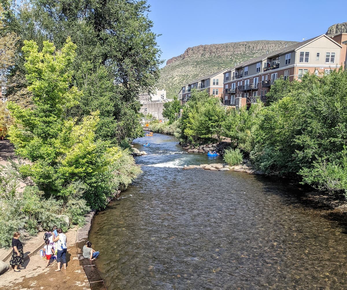
Clear Creek runs through the middle of Golden, a five-minute drive from the trailhead. It's the standard post-hike cool-down on a summer afternoon.
Downtown has coffee, breakfast spots, and the kind of brewery scene you'd expect from the home of Coors, whose plant you looked down on from the rim. If you're building a bigger Front Range hiking week, North Table pairs naturally with the Boulder foothills. It's about 30 minutes to the trails in our best hikes near Boulder guide and to Chautauqua Park under the Flatirons, so you can stack two very different mesas-and-foothills days back to back.
Frequently Asked Questions
How long is the North Table Mountain loop?
The full perimeter loop runs about 7 to 8 miles round trip, depending on how you connect the trails, with roughly 700 to 1,000 feet of elevation gain concentrated in the climb from the West Trailhead. Most hikers finish it in 3 to 4 hours at a relaxed pace.
Where do you park for North Table Mountain?
The main option is the North Table Mountain West Trailhead on Highway 93, a paved lot with restrooms just north of downtown Golden. It fills early on weekends, so arrive by 8 AM or use the North Trailhead farther up Highway 93 as a backup.
Is North Table Mountain a hard hike?
The climb to the rim is short but steep and fully exposed, which surprises people, especially at 6,500 feet. Once you're on top, the trails are nearly flat and easy. The bigger challenge is the heat and lack of shade in summer, not the terrain.
Are dogs allowed on North Table Mountain?
Yes, on a leash no longer than 6 feet, on all trails. Rangers enforce the leash rule, both for the wildlife and because mountain bikes move quickly on the open sections. Bring water for your dog, since there's none on the mesa.
Can you rock climb at North Table Mountain?
Yes. The Golden Cliffs along the southwest face are a popular bolted basalt climbing area. Some routes and cliff-edge trails close for raptor nesting, usually from about February through July, so check current closures at the trailhead or with Jefferson County Open Space before you go.
Final thoughts
North Table Mountain gives you a real Front Range summit feel without a real Front Range effort. You climb hard for one mile, then earn hours of easy, wide-open walking with Golden below and the Divide on the horizon. Get there early for a parking spot, carry more water than you think you need, and check the raptor closures if the cliffs are your goal.
If North Table sold you on quick-hit Front Range hikes, keep going with our best day hikes near Denver guide, and use the Colorado hiking beginner's guide to plan for altitude and afternoon weather before your next one.
Photos: North and South Table Mountain and the caprock cliffs by James St. John (CC BY 2.0); view over Golden by Joshuahicks (CC BY-SA 3.0); Clear Creek in Golden by Dicklyon (CC BY-SA 4.0), via Wikimedia Commons.
Get the Colorado 14er Packing Checklist (free PDF)
Plus a weekly note on the best Colorado trails, gear deals, and seasonal hike picks. No spam, unsubscribe anytime.
We respect your inbox. Unsubscribe anytime.