Mount Princeton Trailhead: The Road, Parking, and How High to Drive
The Mount Princeton trailhead sits above Buena Vista on a dirt road that decides your whole day before you take a single step. There's one lower trailhead at about 8,900 feet where the pavement-friendly driving ends, and then a rough mountain road that climbs another three miles to a set of radio towers at 10,800 feet. How far up that road you can safely drive sets your round-trip distance anywhere from about 3 miles to more than 13. That's the question this page answers: where to park, what your vehicle can handle, and how to drive the road without wrecking your rig five miles from a tow truck.
No permit, no reservation, and no fee are required at any point, which is a relief compared to peaks like Quandary that now charge for parking. The catch is that the road does the gatekeeping instead. Get the driving decision right and Princeton is an approachable Collegiate 14er. Get it wrong and you've either signed up for a long road walk or stranded a low car on a shelf road with nowhere to turn around. For the climb itself, the East Slopes route step by step, see our complete Mount Princeton guide. This page is about getting to the start.
What You'll Learn
- Quick Trailhead Facts
- How High Should You Drive?
- Getting to the Trailhead
- The Lower Trailhead (2WD, 8,900 ft)
- The Radio Towers and the 4WD Road Above
- Driving the Road Without Drama
- Permits, Fees, and Facilities
- When the Road Is Open
- Where to Stay and Camp Nearby
- Where People Go Wrong
- Frequently Asked Questions
Quick Trailhead Facts
- Peak elevation: 14,197 ft, one of the Collegiate Peaks in the Sawatch Range
- Lower trailhead: end of the first stretch of County Road 322, about 8,900 ft
- Radio towers (high parking): about 10,800 ft, roughly 3 miles up the rough road from the lower lot
- Upper road cut (where the trail leaves the road): about 11,800 ft, via the rougher 322A road above the towers
- Round trip from the bottom: about 13.25 miles, 5,400 ft of gain (per the Colorado Fourteeners Initiative at 14ers.org)
- Round trip from the towers: about 6.5 miles, 3,200 ft of gain
- Round trip from the upper cut: about 3 miles
- Vehicle: passenger cars should park low; high-clearance, ideally four-wheel drive, for the towers and above
- Permit or fee: none
- Restrooms and water: none at the trailhead or on the road
- Cell service: spotty low, unreliable up high
- Road season: generally snow-closed November into June
How High Should You Drive?
This is the only planning decision that really matters on Princeton, so start here. The Mount Princeton Road climbs in rough tiers, and your honest assessment of your vehicle and your nerve picks the tier.
If you drive a passenger car or a crossover, park at the lower trailhead near 8,900 feet. The Forest Service is blunt about it: the Pike-San Isabel National Forest page for the peak says passenger vehicles can't travel the rocky road above, and it tells low-clearance drivers to park low and hike. That turns Princeton into a long day, roughly 13 miles round trip with 5,400 feet of gain, most of the lower half on the road itself. It isn't scenic walking, but it's safe and your car survives.
If you drive a high-clearance SUV or truck, ideally with four-wheel drive, you can grind up to the radio towers near 10,800 feet. This is where most people who climb Princeton actually start. The three miles of road to the towers are rocky, slow, and narrow, more of a crawl than a drive, but a capable rig in dry conditions handles it. From the towers it's about 6.5 miles round trip, which is a reasonable 14er day.
If you drive a genuine four-wheel-drive vehicle and you're comfortable on rough shelf roads, you can continue past the towers toward the upper road cut near 11,800 feet. The 322A road above the towers is rougher and more exposed, and it shortens the hike to roughly 3 miles round trip. Parking up there is almost nothing, just a pullout or two, and the driving is the real work. Only take this on if the rough stuff is something you enjoy rather than endure.
When in doubt, park lower. A scraped oil pan or a cracked tire high on this road is a genuine emergency, not an inconvenience.
Getting to the Trailhead
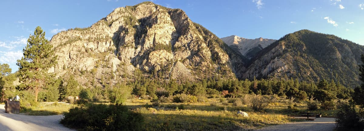
Mount Princeton rises southwest of Buena Vista, above the town of Nathrop and the Chalk Creek valley. The Forest Service directions start from Buena Vista:
- From the center of Buena Vista, drive west on County Road 306 for 0.7 mile
- Turn left (south) onto County Road 321 and follow it for 7.2 miles
- Turn right onto County Road 322 at a large sign
- Drive 0.8 mile on CR 322 to a fork, then bear right into the lower Mount Princeton trailhead
Coming from the south, you can also reach CR 321 from Nathrop, about 8 miles south of Buena Vista on US Highway 285. Turn west onto County Road 162 toward the Mount Princeton Hot Springs, then connect north to CR 321 and the CR 322 turnoff. Either way, CR 322 is the road that climbs the mountain, and the fork just past the lower lot is where you commit to the rough stuff or stop.
Download your maps before you leave the valley. The road isn't complicated, but cell service fades as you climb and you don't want to be second-guessing a junction while inching along a shelf.
The Lower Trailhead (2WD, 8,900 ft)
At the end of CR 322's first 0.8 mile, where you bear right at the fork, there's a parking area around 8,900 feet. This is the practical trailhead for anyone not driving a high-clearance vehicle. The Forest Service calls it a large parking area, so space usually isn't the problem here that it is at the towers.
The base of the road runs past the Young Life Frontier Ranch, which is private land, so respect the posted signs and park only in the designated areas rather than pulling onto private drives or blocking the road. If you're towing anything, leave the trailer down low; there's no room for it higher up, and the road above is no place for a trailer anyway.
Starting from here means walking the road for the first several miles before the trail proper begins. It's a grind of about 13 miles round trip to the summit and back, and plenty of hikers do exactly that rather than risk a car they can't afford to damage. If that's your plan, start in the dark and bring a headlamp, because road miles in the morning cold eat time you'll want on the summit side of noon.
The Radio Towers and the 4WD Road Above
The radio towers at about 10,800 feet are the real staging point for most Princeton climbers. Reaching them means driving roughly 3 miles of rough, rocky road above the lower lot, staying right at the fork and following the main road up. A high-clearance vehicle with four-wheel drive handles it in dry weather; a stock crossover or a car does not.
Parking at the towers is tight. The Forest Service describes room for only a couple of vehicles, and trip reports mention a handful of pullouts at best. On a summer weekend those fill early, and there's no overflow lot up there, so an early arrival matters as much for the parking as for the weather. If the towers are full, you either squeeze into a legal pullout lower down or turn around and start from the bottom.
Above the towers, the 322A road keeps climbing another 1.3 miles or so toward a road cut near 11,800 feet, where the trail finally leaves the road and heads up the east ridge. This upper stretch is a true four-wheel-drive route, narrower and rougher than the road to the towers, and the parking at the top is just a pullout. Driving it trims the hike to about 3 miles round trip, but it's a short drive for a lot of risk, and most people are better off walking the extra road from the towers. For the route above the road cut, our complete Mount Princeton guide covers the traverse and the loose East Slopes talus in detail.
Driving the Road Without Drama
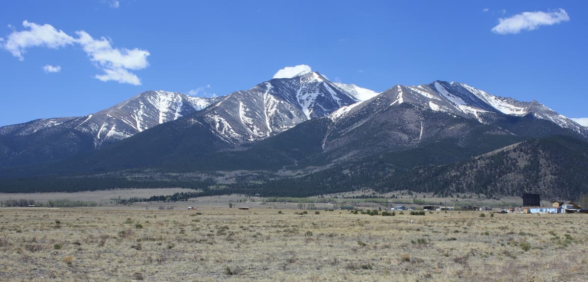
The Mount Princeton Road is narrow, rocky, and two-way, with steep drop-offs and blind corners and almost no room to pass. It climbs by switchbacks and shelf sections where one side is a rising bank and the other is air. None of it is technical in the rock-crawling sense, but it demands slow, deliberate driving and real clearance.
A few things keep it sane:
- There's nowhere to turn around for about 3 miles once you commit above the lower area. Decide at the bottom. If the first rough pitch above the lot already has you white-knuckled, back out and park low. It only gets narrower.
- Yield to downhill traffic and use the pullouts. On a shelf road, the vehicle heading down generally has the harder time backing up, so uphill drivers should find a wide spot and wait. Scout the next pullout as you go.
- Give the drive real time. Plan 30 to 45 minutes of crawling from the pavement to the towers at each end of your day. Fold that into your alpine start so you're not rushing the one part of the trip where rushing does the most damage.
- Air down and slow down on the rock. Most flats and dented rims up here come from speed, not from the road being impossible. A paper Sawatch Range trail map is worth carrying too, since there's no signal to reroute you if you take a wrong spur.
If any of this sounds like more adventure than you want in a stock vehicle, that's the road telling you to park at 8,900 feet and walk. Princeton's road has humbled a lot of optimistic drivers.
Permits, Fees, and Facilities
You don't need a permit, a timed-entry reservation, or a parking fee to climb Mount Princeton. The Forest Service page lists only commercial special-use permits for guiding and outfitting, nothing for a private hiker showing up to park and walk. That sets Princeton apart from the Front Range peaks where access has tightened: Quandary now requires paid parking or a shuttle in summer, and places like Maroon Bells cap and charge for entry. Here it's still first come, first served, with the road as the only real limit.
Facilities are nonexistent on the mountain. There are no restrooms and no water at the trailhead or anywhere on the road, so handle both in Buena Vista or Nathrop before you drive up. Pack out everything, including toilet paper if you have to go on the mountain, because this is loose alpine ground that doesn't hide or break anything down.
For current road or closure questions, the managing office is the Salida Ranger District of the Pike-San Isabel National Forest at 719-539-3591. They're the people to call if you want to know whether the upper road has melted out or whether a storm has closed things early.
When the Road Is Open
The Forest Service says the Mount Princeton Road is closed by snow from November through June. In practice that means the upper road to the towers melts out sometime in June most years, and the stretch above the towers can hold snow and mud later still. By July it's usually dry and drivable to the towers; by late September you're watching for the first snows to shut it down again.
Shoulder-season timing is a guess, so don't count on a specific date. Some sources list a gate closure window as narrow as December 1 to April 15, but snow on the road does the real closing well before and after any posted dates. If you're going in June or October, call the Salida Ranger District or check recent trip reports on 14ers.org before you drive two hours to find the road buried. In full winter the road is a snow route, which turns Princeton into a mountaineering objective rather than a hike.
Where to Stay and Camp Nearby
Most people climbing Princeton sleep nearby the night before, both to acclimatize and to skip a brutal predawn drive from the Front Range. You've got good options at the base.
Buena Vista, about 20 minutes away, is a real town with motels, rentals, restaurants, and gear. It sits around 7,900 feet, high enough to help you adjust before a 14er. The Mount Princeton Hot Springs resort at Nathrop puts you right at the base with lodging and a soak that's even better after the climb than before it.
For camping, the national forest campgrounds along County Road 162 in Chalk Creek Canyon, including the Mount Princeton, Chalk Lake, and Cascade campgrounds, sit close to the base and take reservations through Recreation.gov in season. Dispersed camping is allowed in much of the surrounding national forest if you'd rather sleep for free; our dispersed camping in Colorado guide covers the rules and how to find a legal spot. Wherever you land, you'll still want to be at the trailhead parking early, because sleeping close by doesn't reserve you a space at the towers.
Sleeping high helps with more than convenience. Starting a 14er on no acclimatization is how flatlanders end up sick and slow, so read our altitude sickness guide and give yourself a night up high if you can.
Where People Go Wrong
The mistakes on Princeton almost all happen on the drive, not the hike:
- Driving higher than the vehicle can handle. A car or stock crossover has no business above the lower lot. The Forest Service says as much. Park at 8,900 feet and walk rather than gambling your oil pan on the rocks.
- Committing to the road, then panicking. Once you're a mile up, there's no turning around for a long way. If the first rough pitch scares you, back down to the lot before you're stuck.
- Showing up late for the two or three spots at the towers. The high parking is tiny. Arrive before dawn or plan to start lower.
- Forgetting the drive in the time budget. The slow crawl to the towers adds the better part of an hour at each end. Hikers who don't plan for it end up on the exposed upper slopes when afternoon storms build.
- Counting on a signal or a bathroom. Neither exists up here. Download maps, and take care of business in town.
Handle the road honestly and Princeton rewards you with a Class 2 climb and a front-row view over Buena Vista and the Arkansas Valley. For the climb itself and what to pack for the loose talus up high, including trekking poles for the slide back down, see the complete Mount Princeton guide, and check the Mount Princeton weather page for why you want to be off the summit by noon.
Frequently Asked Questions
Where do you park to hike Mount Princeton?
Passenger cars and crossovers should park at the lower trailhead near 8,900 feet, at the end of the first 0.8 mile of County Road 322. High-clearance four-wheel-drive vehicles can continue about 3 rough miles to the radio towers at 10,800 feet, where there's room for only a couple of vehicles. The Forest Service directs low-clearance drivers to park low and hike.
Can you drive to the top of Mount Princeton?
No. The road climbs to a cut near 11,800 feet where the trail leaves it, and from there you hike about 3 miles round trip to the 14,197-foot summit. A capable four-wheel-drive vehicle can reach that upper road cut, but the top of the mountain is on foot only, up loose Class 2 talus.
Do you need 4WD for the Mount Princeton trailhead?
You don't need it to reach the lower trailhead at 8,900 feet, but you do to drive any higher. The Forest Service says passenger vehicles can't handle the rocky road above the lower lot. A high-clearance vehicle, ideally with four-wheel drive, is what gets you to the radio towers and shortens the hike.
Is the Mount Princeton road open?
The road is generally closed by snow from November through June. It usually melts out and becomes drivable to the radio towers by July and stays open into the fall until early snows shut it down. Shoulder-season timing varies year to year, so call the Salida Ranger District at 719-539-3591 or check recent trip reports before a June or October trip.
Are there bathrooms at the Mount Princeton trailhead?
No. There are no restrooms and no water at the lower trailhead, the radio towers, or anywhere on the road. Take care of both in Buena Vista or Nathrop before you drive up, and pack out everything if you have to go on the mountain.
Final Thoughts
Mount Princeton's trailhead comes down to one honest question: how high can you safely drive? Park at 8,900 feet and you get a long but safe 13-mile day. Reach the radio towers in a capable high-clearance rig and it's a reasonable 6.5-mile climb. There are no permits and no fees to sort out, just a rough road, tiny parking up high, and an early alarm.
Once the drive and parking are handled, the mountain is the reward. For the route step by step, see the complete Mount Princeton guide, check conditions on the weather page, and if you're stringing together Collegiate summits, read up on neighboring Mount Yale and the rough-road twin Mount Antero. To see where Princeton ranks against the rest, our 14ers by difficulty guide puts it in context.
Get the Colorado 14er Packing Checklist (free PDF)
Plus a weekly note on the best Colorado trails, gear deals, and seasonal hike picks. No spam, unsubscribe anytime.
We respect your inbox. Unsubscribe anytime.