Best Hikes in Indian Peaks Wilderness: 8 Trails for 2026
Indian Peaks Wilderness is the 76,000-acre stretch of the Front Range where the Continental Divide turns into a wall of jagged peaks west of Boulder and Nederland. Locals have known about it for decades. Most out-of-state visitors drive right past it on their way to Rocky Mountain National Park next door, which is exactly why the alpine lakes here still feel like a secret on a Tuesday morning.
If you've already done the Bear Lake corridor in RMNP and want the same kind of glacier-carved scenery without the timed-entry pinball, this is the place. The trade-off is a different permit system, a strict bear canister rule that the rangers actually enforce, and trailhead access that requires a little more planning than just showing up.
Here are the eight Indian Peaks hikes worth your time in 2026, plus the permit and parking specifics that catch most first-timers off guard. If you're still deciding between the two areas, our Rocky Mountain National Park vs Indian Peaks Wilderness comparison covers the trade-offs in detail.
What You'll Learn
- Lake Isabelle
- Pawnee Pass to Pawnee Lake
- Diamond Lake
- Mount Audubon
- Lost Lake
- King Lake via Hessie
- South Arapaho Peak
- Lake Dorothy
Permits, Parking, and Fees
Indian Peaks Wilderness is split between the Brainard Lake Recreation Area on the east side and a handful of smaller trailheads on the south and west. The rules vary by entry point and they change a few times each summer, so this is worth reading before you drive up.
Brainard Lake Recreation Area (Long Lake, Mitchell Lake, and Niwot trailheads) requires a timed-entry reservation from late May through mid-October. Reservations cost about $15 per vehicle for day use and are booked through recreation.gov, typically released in two-week rolling windows. The gate at the entrance station scans your reservation. There's no walk-up option in peak season.
Hessie Trailhead outside Eldora has no reservation system but has very limited parking. Eldora locals have been pushing back against trailhead overflow for years, so the rangers and the Nederland RTD Park-n-Ride run a free shuttle on summer weekends. Use it. Parking on the road below Hessie has a tow-zone rule that's enforced.
Fourth of July Trailhead west of Nederland is the launching point for Diamond Lake, South Arapaho Peak, and Lake Dorothy. The road is rough, narrow, and high-clearance only for the last four miles. Most sedans turn around at the lower lot and add three miles each way to their day. A standard SUV makes it. AWD helps after rain.
Backcountry permits are required for overnight stays from June 1 through September 15, also booked through recreation.gov.
Bear canisters are required in the eastern half of the wilderness, from the Camp Dick area west to Pawnee Pass. The rule has been in place since 2002 because of repeated bear conflicts at the popular alpine lake campsites. Rangers do spot-check at the trailheads and in camp. Our best bear canisters for Colorado guide breaks down what passes muster. Dogs are allowed on leash, group size caps at 12, and no campfires above 10,400 feet.
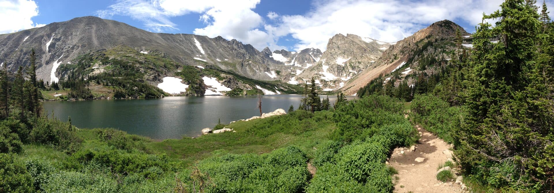
Lake Isabelle
The easiest big-payoff hike in the wilderness, and the right pick for anyone who only has one day in Indian Peaks. The trail leaves from the Long Lake trailhead inside the Brainard Lake Recreation Area, winds along the north shore of Long Lake through subalpine fir, then climbs gently to Isabelle Glacier's outflow basin. You're at 10,868 feet at the lake with Navajo, Apache, and Shoshoni peaks rising right out of the water behind it.
Trail stats: 4.0 miles round trip, 400 ft elevation gain, easy to moderate. Allow 2 to 3 hours.
Wildflower peak is mid-July. Marsh marigolds carpet the boggy meadows below the lake, then the higher tundra explodes with paintbrush and columbine through early August. The trail is family-friendly to the lake, and most parents turn around there rather than continuing up to the glacier.
Crowds are real. The Long Lake lot fills before 7 AM on summer Saturdays even with the reservation cap. Book the earliest entry slot, plan to be on the trail by 6:30, and you'll have the lake mostly to yourself for an hour before the day-trippers arrive. Afternoon thunderstorms roll in by 1 PM most days, so a sunrise start is also the safer call.
Pawnee Pass to Pawnee Lake
The signature long day in Indian Peaks. The route shares the first mile with Lake Isabelle, then breaks off and climbs the long talus switchbacks to Pawnee Pass at 12,541 feet. From the pass you drop into the west-side basin and Pawnee Lake at the foot of Pawnee Peak. The full out-and-back to the lake is a serious day.
Trail stats: 9.0 miles round trip to Pawnee Lake, 2,400 ft elevation gain, strenuous. Allow 6 to 8 hours.
The pass itself is one of the best Continental Divide crossings in Colorado. You're looking straight down into the Cascade Creek drainage on the west side with the Gore Range visible on a clear day. Most hikers turn around at the pass, which makes the 7-mile round trip to the pass a popular shorter option at 2,000 feet of gain.
If you're acclimated, set out at 5:30 AM from the Long Lake trailhead. The exposure above treeline is significant and there's no good place to shelter once you're past mile 2.5. A solid pair of hiking boots helps on the loose talus near the pass.
Snow lingers in the upper switchbacks into early July most years. Check the Boulder Ranger District trail conditions page before you commit.
Diamond Lake
The Fourth of July side of Indian Peaks gets a fraction of the Brainard Lake traffic, and Diamond Lake is the reason regulars keep coming back. The trail starts at the Fourth of July trailhead at 10,120 feet, drops to cross the North Fork Middle Boulder Creek, then climbs through subalpine forest and willow meadows to the lake at 10,950 feet.
Trail stats: 5.5 miles round trip, 900 ft elevation gain, moderate. Allow 3 to 4 hours.
The lake sits in a wide basin with views west to the Continental Divide and a small waterfall feeding the inlet. Wildflowers in July rival Lake Isabelle and you'll usually see one-tenth the people. The catch is the road. Fourth of July Road past the Buckingham Campground turnoff is rough enough that low-clearance cars genuinely shouldn't attempt it.
Best window is mid-July through early September. Snow blocks the upper switchbacks until late June most years. Mosquitoes are heavy in the boggy meadows below the lake for about two weeks after melt-out, so a head net is worth the ounce.
Mount Audubon
The most-hiked 13er in the Front Range outside the I-70 corridor, and a genuine summit you can knock out as a day hike if you're acclimated. The trail leaves from the Mitchell Lake trailhead inside Brainard Lake Recreation Area and climbs steadily through krummholz, then up the long east shoulder to the summit at 13,229 feet.
Trail stats: 7.6 miles round trip, 2,720 ft elevation gain, strenuous. Class 2. Allow 5 to 7 hours.
The summit views are the payoff. You're looking straight down at the chain of lakes you just hiked past, with Longs Peak filling the northern horizon and the rest of Indian Peaks spread out below. The hardest section is the final 800 feet across loose summit talus, where the trail braids into a half-dozen routes that all end in the same place.
Start early. Storms in the Audubon area routinely build before noon in July and August, and there is nowhere to hide above treeline. A 5 AM trailhead departure means you can be off the summit by 10. If you're new to altitude, our altitude sickness prevention guide covers the basics worth knowing before you head above 12,000 feet.
Lost Lake
The family hike in Indian Peaks. The trail starts at the Hessie trailhead outside Eldora, follows the old wagon road past two small waterfalls, then climbs through aspen and lodgepole pine to Lost Lake at 9,790 feet. The lake itself is small and ringed by forest, with Bryan Mountain rising behind it.
Trail stats: 4.0 miles round trip, 700 ft elevation gain, easy. Allow 2 to 3 hours.
The waterfalls in the first half mile are the highlight for kids. Both are easy to scramble close to, and the spray makes the willow meadow below them genuinely magical on a hot July afternoon. The grade is gentle, the footing is good, and the lake makes a perfect lunch stop.
Use the Eldora shuttle from the Nederland RTD Park-n-Ride on summer weekends. The Hessie lot is small, the access road is single-lane, and trying to drive in on a Saturday is a recipe for getting blocked in. The shuttle is free and runs every 30 minutes through the summer season.
King Lake via Hessie
The long one out of Hessie. The trail follows the South Fork Middle Boulder Creek through a chain of alpine meadows, climbs past Betty and Bob lakes, then tops out at King Lake at 11,431 feet directly under the Rollins Pass railroad grade and the Continental Divide.
Trail stats: 12.0 miles round trip, 2,200 ft elevation gain, strenuous. Allow 7 to 9 hours.
This is one of the best long day hikes in the wilderness if you can handle the mileage. The terrain shifts five or six times. Cottonwood-lined creek bottom, willow meadows, subalpine forest, krummholz, then full tundra at the lake. King Lake is also a popular overnight destination for backpackers, and the higher tarns above it are worth the extra effort if you have it in you.
Bring a solid daypack and treat this as a full day. Start before sunrise if you want to be off the high stretches before afternoon storms. Snow lingers around the lake into mid-July most years. If you're carrying overnight gear, the bear canister rule applies through this entire drainage.
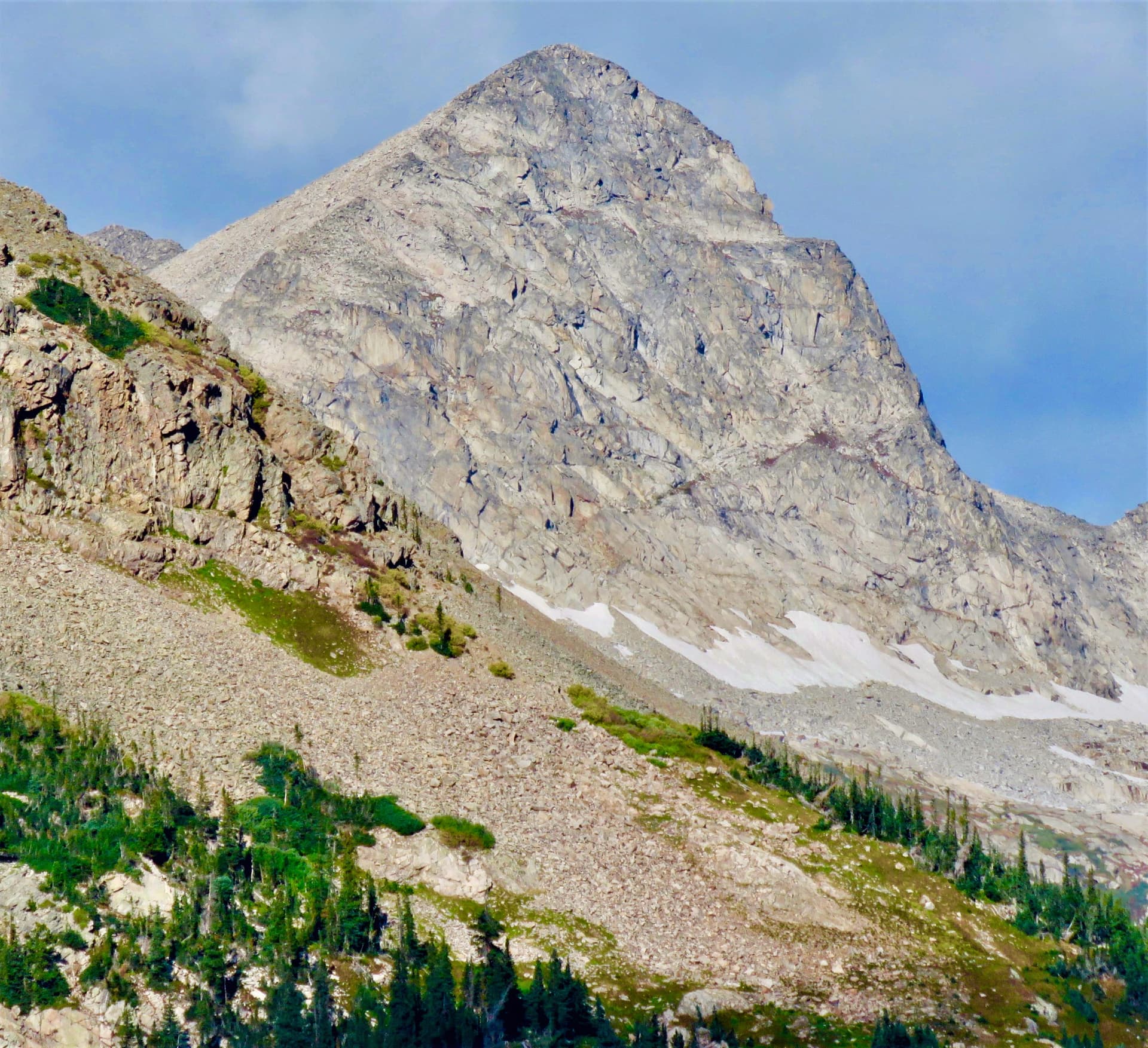
South Arapaho Peak
The most accessible 13er in Indian Peaks, and a route with one of the best summit views on the Front Range. The trail leaves from the Fourth of July trailhead, climbs steadily past the old Fourth of July Mine ruins, then follows a well-cairned route up the east ridge to the summit at 13,397 feet.
Trail stats: 7.5 miles round trip, 3,000 ft elevation gain, strenuous Class 2. Allow 5 to 7 hours.
The route stays Class 2 the entire way if you stick to the cairns. There's no exposure to speak of, but the upper third is loose talus where every step takes intention. The summit views down into the Arapaho Glacier basin are the kind of thing that makes you understand why Boulder named its watershed after this peak.
Snow stays on the upper route into mid-July, sometimes later. Microspikes and an ice axe are a smart call before mid-July, and our microspikes guide covers what works at this elevation. Storms build early on the ridge, so a 4:30 AM start from the trailhead is the right play in July and August.
Lake Dorothy
The third trail off the Fourth of July trailhead, and the highest of the three. The route shares the first 2.5 miles with the South Arapaho Peak trail, then breaks off below the mine and climbs into the alpine basin under Arapaho Pass. Lake Dorothy sits at 12,061 feet, the highest named lake in the wilderness.
Trail stats: 6.0 miles round trip, 2,300 ft elevation gain, moderate. Allow 4 to 5 hours.
The lake is small, deep, and surrounded by tundra. You're well above treeline by the time you reach it, with views east across the Roaring Fork drainage and west to the Arapaho Pass crossing of the Divide. It's quiet most days. The South Arapaho summit crowd peels off at the junction and the rest of Fourth of July traffic stops at Diamond Lake.
Best window is mid-July through mid-September. The basin holds snow late and the wind cuts hard at 12,000 feet, so a packable rain shell and warm layers matter even on bluebird July days.
How to Choose
If you've never hiked above 10,000 feet: Start with Lost Lake or Lake Isabelle. Both are well below the storm-building elevations and the trailheads have water and bathrooms.
If you have one good day: Lake Isabelle on a sunrise reservation. The drive in, the wildflower meadows, and the view at the lake hit every Indian Peaks highlight.
If you want a summit: Mount Audubon for first-time 13er hikers, South Arapaho Peak for anyone with prior altitude days.
If you want quiet: Diamond Lake, Lake Dorothy, or King Lake. The Fourth of July and Hessie sides see a fraction of the Brainard traffic.
If you're hiking with kids: Lost Lake from Hessie, with the waterfalls in the first mile, then the lake for lunch.
If you have a backpacking permit: King Lake or Pawnee Lake. Both have established campsites in the alpine basin, both require the bear canister, and both turn into completely different experiences when you're there for sunrise.
Where to Stay Nearby
Nederland is the closest mountain town to both the Brainard Lake and Hessie trailheads, about 20 minutes uphill from Boulder. The Caribou Village area has cabin rentals and a couple of small motels. Most lodging here is short-term rentals. Our Nederland hiking guide covers the local trail network and town basics.
Allenspark is the closer base for the north end of the wilderness near Brainard Lake and Wild Basin. It's a small unincorporated community on the Peak to Peak Highway with a few cabin rentals and the Allenspark Lodge.
Camp Dick Campground on Middle Saint Vrain Creek is the most popular Forest Service campground in the area, with 41 sites that book up two months out on recreation.gov. Olive Ridge Campground a few miles north is a good backup. Both are at about 8,600 feet so you'll feel the altitude sleeping there.
Boulder itself is a 45-minute drive to the Brainard gate. Plenty of hotel options, plenty of food, but you're trading the longer morning drive for the urban amenities. Our hikes near Boulder guide has the city's own hiking network if you want a recovery day.
What to Bring
Indian Peaks weather changes fast. Even in July, summit temperatures sit in the 30s with 30 mph winds while it's 75 and sunny at the trailhead. Pack for the high terrain, not the parking lot.
The basics every Indian Peaks day pack should have:
- Sturdy hiking boots with ankle support for the loose talus on Audubon, Arapaho, and Pawnee Pass
- A packable rain shell (afternoon storms are routine June through September)
- Extra warm layer (the wind at the high passes is genuinely cold)
- Water plus a water filter for refills at the lakes
- Sun protection (the UV at 12,000 feet burns faster than people expect)
- Map or GPS (cell service is unreliable past the trailheads)
- Headlamp (alpine starts mean the first hour is in the dark)
- Bear canister if overnighting in the eastern half
If you're new to Colorado hiking, our beginner's guide to Colorado hiking covers the pacing, water, and layering basics that turn most first-attempt summits into successful ones.
For backpacking trips, the bear canister rule is not optional in the eastern half of the wilderness. Rangers check.
FAQs
Do I need a bear canister in Indian Peaks Wilderness?
Yes, if you're camping overnight in the eastern half of the wilderness. The bear canister rule has been in effect since 2002 and covers the area from Camp Dick west to Pawnee Pass, which includes most of the popular alpine lake campsites. Rangers do check at the trailheads and in camp. Day hikers don't need one.
How do I get a Brainard Lake reservation?
Through recreation.gov. The Brainard Lake Recreation Area releases timed-entry reservations in rolling two-week windows during the season, which runs from late May through mid-October. Day-use is about $15 per vehicle. Reservations for summer weekends release about two weeks out and they go quickly, especially the early-morning slots. Weekday slots are easier to grab.
Are dogs allowed in Indian Peaks Wilderness?
Yes, on leash. This is one of the biggest differences from Rocky Mountain National Park next door, where dogs are not allowed on trails at all. The leash rule is enforced by Forest Service rangers, particularly in the Brainard Lake area where wildlife conflicts have been an issue.
What's the hardest hike in Indian Peaks?
By the numbers, the full Pawnee Pass to Crater Lake traverse (which crosses the Divide and descends to the west side) or the South Arapaho to North Arapaho ridge traverse. As single-trail day hikes from a trailhead, South Arapaho Peak is the hardest at 3,000 feet of gain to a Class 2 summit. Mount Audubon is close behind.
When does the snow melt in Indian Peaks?
Lake-level trails (Isabelle, Diamond, Lost) usually melt out by late June. Pass crossings and 13er routes (Pawnee Pass, South Arapaho, Audubon) hold snow into mid-July most years and sometimes later. The Boulder Ranger District posts trail-condition updates that are worth checking the week before you go.
Is Indian Peaks Wilderness better than Rocky Mountain National Park?
For experienced Colorado hikers who value solitude, dog access, and lower costs, yes. For first-time visitors who want the iconic national park experience and named destinations like Bear Lake and Sky Pond, RMNP is the better pick. Our side-by-side comparison breaks down which one fits which kind of trip.
The Bottom Line
Indian Peaks Wilderness is the Front Range hiking destination that delivers RMNP-quality alpine terrain with a fraction of the foot traffic, but the bear canisters and the Brainard Lake reservation system mean you can't wing it. Plan two to three weeks ahead, start at sunrise, and pick the trailhead that matches your driving setup.
Lake Isabelle is the right first hike. Mount Audubon is the right first summit. Diamond Lake is the right escape from the Brainard crowds. Pick one, get a reservation, and go.
If this guide helped, our best alpine lakes in Colorado and hikes near Boulder posts cover more Front Range territory worth your time.
Get the Colorado 14er Packing Checklist (free PDF)
Plus a weekly note on the best Colorado trails, gear deals, and seasonal hike picks. No spam, unsubscribe anytime.
We respect your inbox. Unsubscribe anytime.