Best Hikes Near Vail, Colorado
Vail and the broader White River National Forest contain over 1,200 miles of trail across the Gore Range, Sawatch, and Eagles Nest Wilderness.
Booth Falls
A beautiful waterfall hike through aspen and conifer forests leading to a 60-foot cascade. Popular among Vail visitors for its accessibility and scenery.
Pitkin Lake Trail
A challenging hike in the Eagles Nest Wilderness climbing nearly 3,000 feet to a stunning alpine lake. The trail offers dazzling views of East Vail and the surrounding peaks, with the final approach through open alpine terrain.
Booth Lake Trail
Extends beyond popular Booth Falls into the Eagles Nest Wilderness backcountry to a beautiful alpine lake surrounded by rugged peaks. Wildflower meadows and wildlife viewing opportunities reward those who push past the falls.

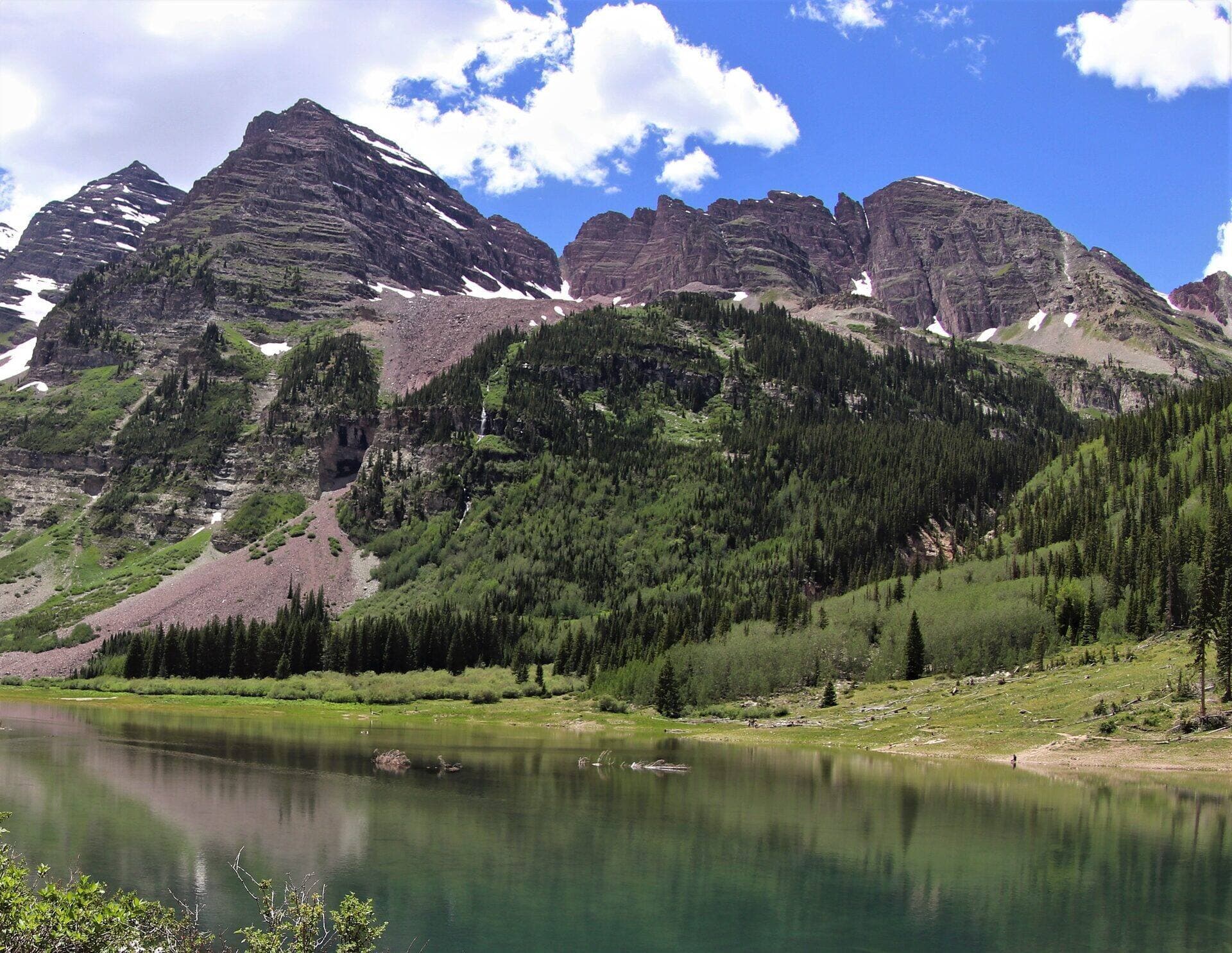
Gore Lake Trail
A long and rewarding hike through the Eagles Nest Wilderness to a remote alpine lake beneath the dramatic Gore Range. Stunning fall colors, rocky terrain, and wildlife sightings make this a Vail-area classic for experienced hikers.
Notch Mountain Trail
Climb to the summit of Notch Mountain in the Holy Cross Wilderness for one of Colorado's most iconic views: the cross-shaped snow couloir on Mount of the Holy Cross. A historic stone shelter sits at the top.
Upper Piney River Falls Trail
A scenic, family-friendly trail following the Piney River past Piney Lake through open wildflower meadows, aspen stands, and pine forests. The waterfall at the end is a refreshing reward with views of the Gore Range.
Missouri Lakes and Fancy Lakes Loop
A stunning loop through the Holy Cross Wilderness visiting multiple alpine lakes and crossing Fancy Pass at 12,005 feet. The route passes through pristine forests, wildflower meadows, and offers views of the Sawatch Range.
Gore Creek Trail to Red Buffalo Pass
Follow Gore Creek deep into the Eagles Nest Wilderness through meadows, aspen groves, and conifer forests to Red Buffalo Pass. The first 4 miles are relatively gentle before the trail steepens significantly toward the pass.
Lake Constantine Trail
From the Half Moon Trailhead near the Mount of the Holy Cross, climb to Lake Constantine. The lake sits at 11,400 feet below Notch Mountain. Famous alpine lake in the Holy Cross Wilderness.
Half Moon Trail
From the Half Moon Trailhead, climb to Half Moon Pass with views of Mount of the Holy Cross. The standard approach for the 14er summit attempt, or stop at the pass for the views. East Cross Creek camps are below for backpackers.
East Cross Creek Trail
From the Half Moon Pass area, descend into East Cross Creek valley with views back to Mount of the Holy Cross. The standard backpacker approach for Holy Cross attempts; East Cross Creek camp is at the base of the standard route.
Berry Creek Trail
Local Vail Valley trail from Edwards climbing through pine and aspen forest along Berry Creek. Popular with mountain bikers in summer; quieter for hikers in shoulder seasons. Connector to the broader USFS trail system above Vail.
Mount of the Holy Cross (North Ridge)
Named for the cross-shaped snow couloir visible in spring. Standard route crosses Half Moon Pass (twice: once on the way in, once on the way out), making this one of the harder 14er days for the distance.
Hiking in Vail: what to know
Vail's hiking divides between Vail Mountain itself (gondola-accessible, easy summer trails), the lower Gore Range (Booth Falls, Pitkin Lake, Gore Creek Trail), and the bigger Eagles Nest Wilderness destinations (Red Buffalo Pass, Slate Lake, Upper Piney Lake).
The Booth Falls / Booth Lake corridor is the most popular local hike. Booth Falls is about 2 miles in; Booth Lake is another 2 miles past the falls. The trailhead lot is small and fills early; the town shuttle stops within walking distance.
For the bigger backcountry days, Pitkin Lake Trail (8 miles round trip, 2,800 feet of gain) and Gore Creek Trail to Red Buffalo Pass (14 miles round trip) are the area classics. Both require an early start and full backcountry preparation.
Vail Mountain accesses some of the easier hiking via the Eagle Bahn Gondola from Lionshead Village. Ride up, hike around the top, and ride down. The Berry Picker Trail descends 2,200 feet from the top of the mountain to town if you want a one-way option.
Edwards (15 minutes west of Vail) has Berry Creek Trail and a network of mountain-bike-shared trails for less crowded local hiking.
Holy Cross Wilderness, south of Vail, contains Notch Mountain Trail (with the famous view of Mount of the Holy Cross) and the Missouri Lakes/Fancy Lakes Loop. Trailheads are 45 minutes from Vail and require high-clearance vehicles for the last stretches.
Vail Pass (10,662 feet) is a popular winter snowshoeing destination with parking right off I-70. The Vail Pass Recreation Area requires a permit in winter.
Like Aspen, Vail in summer means starting early. The afternoon thunderstorms are real. Plan to be at the trailhead by 6 AM for anything above treeline.