Browns Creek Trail, Colorado: A Complete Guide to Browns Creek Falls

Browns Creek Trail gives you one of the better waterfall payoffs in the Sawatch Range without asking for a brutal climb. The most popular trip runs about 5.8 miles round trip from the Browns Creek Trailhead near Nathrop, gains roughly 940 feet, and ends at a two-tiered waterfall tucked into a rocky little canyon. It's free, dogs are welcome, and it sits a short drive from both Buena Vista and Salida. If you keep going past the falls, the same trail climbs to Browns Lake and links up with the standard route on Mount Antero, a 14er.
Here's everything you need to plan the hike, whether you just want the falls or you're eyeing the high country above them.
What You'll Learn
- Browns Creek Falls Quick Facts
- Where Is Browns Creek Falls?
- How to Get to the Browns Creek Trailhead
- How Long and Hard Is the Hike?
- What to Expect on the Trail
- Hiking Past the Falls to Browns Lake
- Browns Creek as a Route Up Mount Antero
- Best Time to Hike Browns Creek Falls
- What to Bring
- Hiking with Dogs and Camping
- Frequently Asked Questions
Browns Creek Falls Quick Facts
Before you load up the car, here's the shape of the standard hike to the falls:
- Distance: about 5.8 miles round trip (out and back to the falls)
- Elevation gain: roughly 940 feet
- Trailhead elevation: about 8,900 feet
- Difficulty: moderate; the first mile is the steep part
- Time: 2.5 to 3.5 hours for most hikers
- Trail number: Browns Creek Trail #1429 (San Isabel National Forest)
- Fee: none
- Dogs: allowed (leash near the trailhead and other hikers)
- Location: Sawatch Range, near Nathrop and Buena Vista in Chaffee County
The numbers stay friendly because most of the climbing happens early. Once you're past the first mile or so, the grade mellows out and the walk to the falls feels easy. That said, you're starting near 9,000 feet, so flatlanders will still notice the thin air.
Where Is Browns Creek Falls?
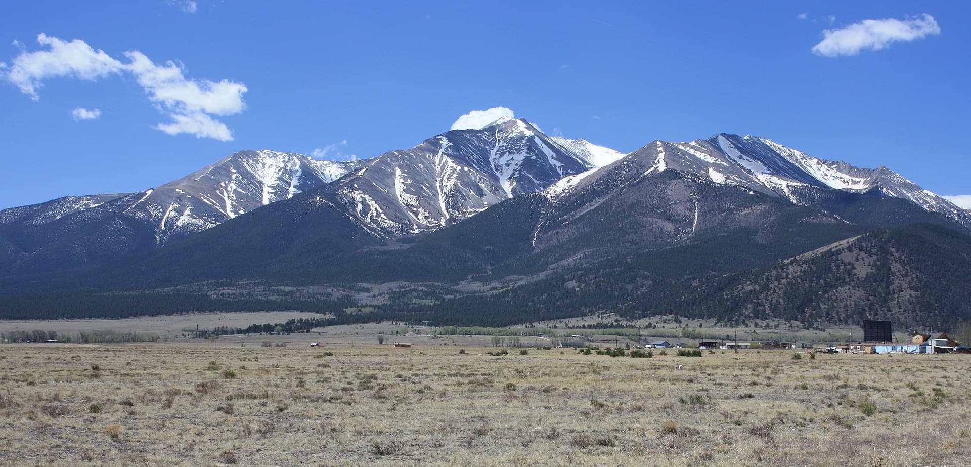
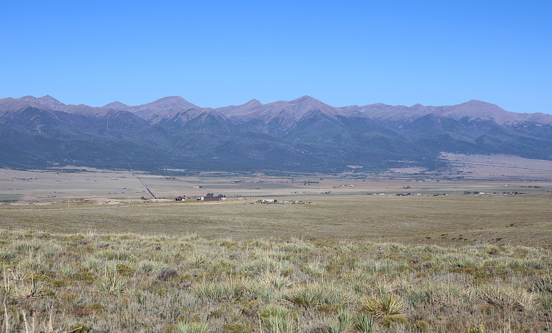
Browns Creek Falls sits on the eastern slope of the Sawatch Range in the San Isabel National Forest, just south of Mount Antero. The trailhead is near Nathrop, the tiny crossroads between Buena Vista and Salida along US 285. This is collegiate country, so you're surrounded by some of the tallest peaks in Colorado, including a cluster of 14ers you can read about in our Colorado 14ers guide.
The creek itself drains the high basins below Mount Antero and Mount White, then tumbles east toward the Arkansas River valley. The falls are the obvious turnaround point for day hikers, but the trail is really a gateway into a much bigger network. It ties into the Colorado Trail and the Wagon Loop Trail, and it eventually reaches Browns Lake high in the basin.
If you like the idea of a waterfall hike in this part of the state, it pairs well with the other cascades on our list of the best waterfall hikes in Colorado.
How to Get to the Browns Creek Trailhead
From Nathrop, head south on US 285 for a couple of miles, then turn west onto County Road 270. Follow it until it bends and becomes Forest Service Road 272, a dirt road that's usually fine for a standard car when it's dry. After a few miles you'll reach the Browns Creek Trailhead parking area on the right.
A few things worth knowing before you go:
- The dirt road can get rough. It's passable for most cars in summer, but go slow over the washboard and rocks. After heavy rain or in early spring, clearance helps.
- The lot is small. It fills on summer weekends, especially when the waterfall is running strong. Get there before 9 AM for a spot and a quieter trail.
- There's a vault toilet at the trailhead, but no water, so bring your own.
Plug "Browns Creek Trailhead" into your map app and it'll route you there. Download the map before you leave town, since cell service drops off once you turn onto the forest roads. A paper backup never hurts; see our roundup of Colorado trail maps if you want one for the area.
How Long and Hard Is the Hike?
The round trip to the falls is about 5.8 miles with roughly 940 feet of gain, which lands it squarely in moderate territory. The catch is that the climb is front-loaded. You'll knock out close to 500 of those feet in the first mile, on a rocky, sometimes steep tread. It's the kind of start that has you questioning your life choices, then rewards you with an easy stroll the rest of the way.
After that first push, the trail flattens into a gentle grade through the forest. Kids who hike regularly can handle it, and most reasonably fit adults will reach the falls in about an hour and a half. The altitude is the real variable. If you drove up from Denver or somewhere lower that morning, take it slow on the steep section and drink more water than you think you need. Our guide to altitude sickness in Colorado covers the warning signs if you're new to hiking up high.
What to Expect on the Trail
The hike starts in a dry, sunny stretch of ponderosa pine. As you gain elevation, the forest shifts to spruce and fir, and patches of aspen turn gold in late September. The first mile climbs through this lower forest with a few rocky viewpoints where you can look back across the Arkansas valley toward the Sangre de Cristo Mountains.
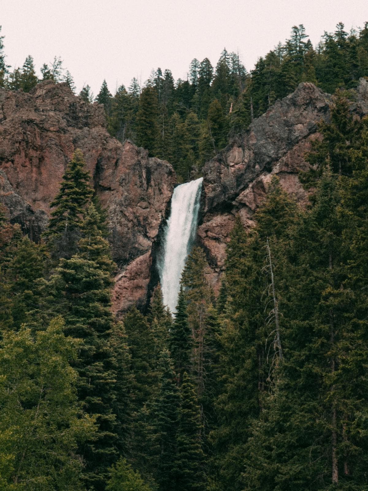
Once the grade eases, you'll walk alongside Browns Creek through meadows and shaded woods. The creek is a steady companion, with small cascades and pools the whole way up. About three miles in, a short spur drops you to the base of Browns Creek Falls, a two-tiered cascade framed by canyon walls. In late spring and early summer it really roars, fed by snowmelt from the peaks above.
It's a great lunch spot. There are rocks and logs to sit on, the spray keeps things cool, and the sound drowns out everything else. Watch your footing on the wet rock near the base, since it stays slick even on warm days.
Hiking Past the Falls to Browns Lake
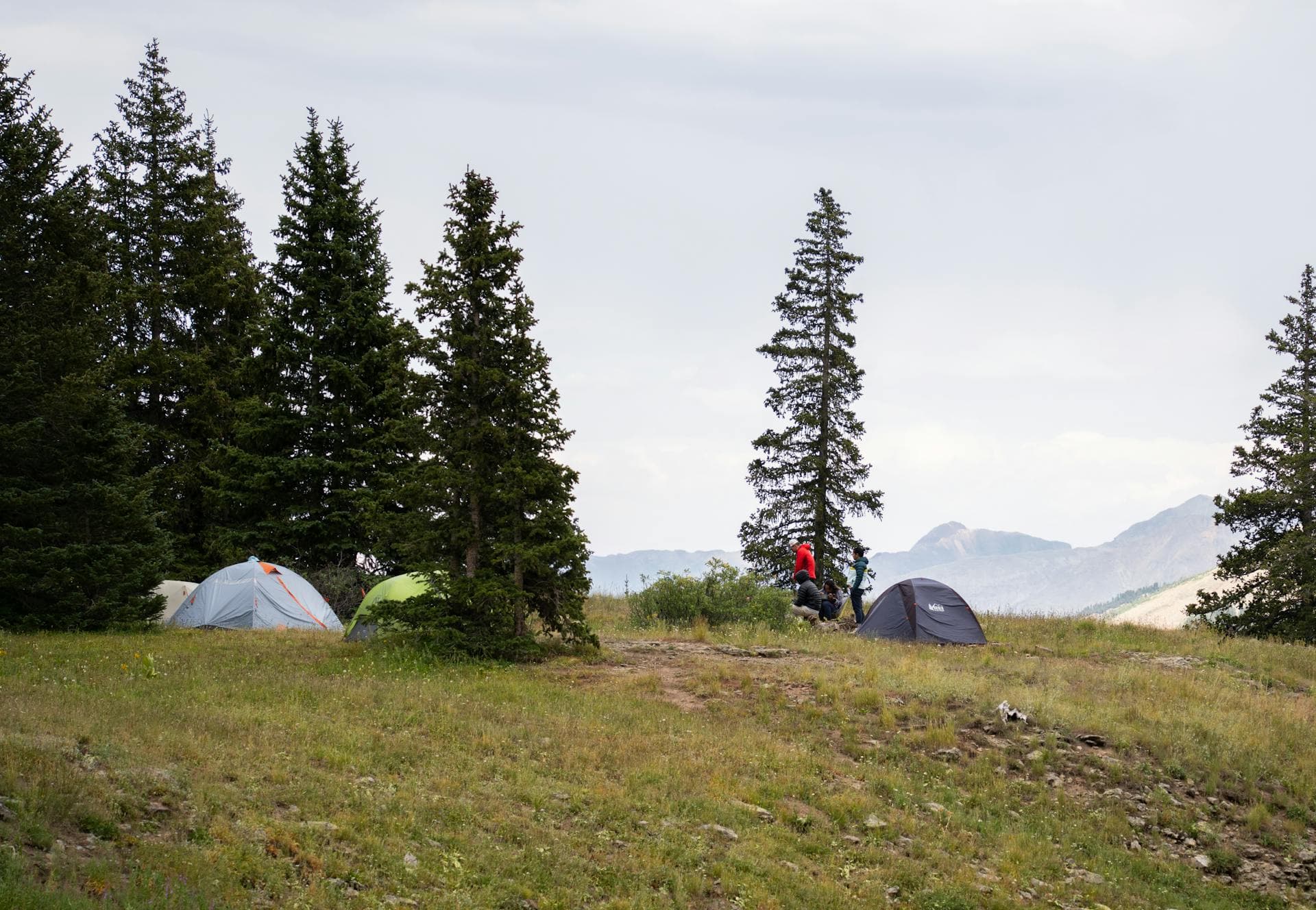
The falls are where most people turn around, but the trail keeps climbing toward the high basin. If you push on, the forest opens into wide alpine meadows, and the views of the surrounding peaks get bigger with every switchback. Wildflowers fill these meadows through July and into August, and the clear pools along the creek hold native trout.
Going all the way to Browns Lake turns this into a long day, closer to 14 miles round trip with a serious chunk of elevation gain, so treat it as a different hike than the falls trip. Many people split it into an overnight, camping in the meadows below the lake and finishing the climb in the morning. The lake sits in a quiet bowl ringed by talus and tundra, the kind of place that makes the extra miles feel worth it. If alpine lakes are your thing, our list of the best alpine lakes in Colorado has more like it.

Browns Creek as a Route Up Mount Antero
The Browns Creek drainage is also a back door to Mount Antero, a 14,269-foot peak famous for the aquamarine and topaz crystals found on its slopes. The standard hiking route uses the Little Browns Creek Trail, which splits off lower down and climbs into the basin between Antero and Mount White before joining the high jeep road near the summit.
This is a big day, often 14 to 16 miles round trip with more than 5,000 feet of gain depending on where you start, so it's a real 14er objective and not a casual extension of the falls hike. Most climbers backpack partway in and camp to break it up. If you're working toward your first big summit, read our Mount Antero complete guide for the full route breakdown, and the easiest 14ers for beginners if you want something gentler first.
Best Time to Hike Browns Creek Falls
Late May through early July is prime time for the waterfall, because that's when snowmelt has the falls at full volume. The lower trail melts out early thanks to its sunny, south-facing start, so you can usually reach the falls weeks before the high country opens up.
Here's how the seasons play out:
- Spring (May to June): The falls are at their loudest. The lower trail is clear, but the upper basin and Browns Lake are still buried in snow. Expect mud and a few creek crossings running high. It's one of the better spring waterfall hikes in Colorado.
- Summer (July to August): Meadows bloom, the whole trail is open, and you can push past the falls to the lake. Start early to beat the afternoon thunderstorms that build over the Sawatch almost daily.
- Fall (September to early October): Aspens turn gold, crowds thin out, and the weather is often crisp and clear. The falls run lower but the color makes up for it.
- Winter: The road and trail get snow and the trailhead access gets dicey. It becomes a snowshoe trip for the prepared, not a casual outing.
What to Bring
This is a half-day hike for the falls, but you're still in the mountains, so pack like it. Afternoon storms move in fast and the temperature swings hard once clouds roll over.
- Layers. A warm midlayer and a rain jacket belong in your pack even on a bluebird morning.
- Trekking poles. They take the sting out of that steep first mile, especially on the way down. Compare options in our trekking poles guide or grab a budget pair with a quick trekking poles search.
- Water and a filter. There's none at the trailhead, and the creek isn't safe to drink straight. Carry two liters and a water filter if you plan to refill. A simple hiking water filter handles the creek.
- Sun protection. That ponderosa stretch is exposed. Pack sunscreen, sunglasses, and a hiking hat.
- Bug spray. The meadows above the falls get buggy in midsummer. Toss in insect repellent.
- The ten essentials. Map, headlamp, first aid, and snacks round it out, plus bear spray if you're heading deep into the basin.

Hiking with Dogs and Camping
Dogs are allowed on Browns Creek Trail, and it's a great one for them. The creek runs alongside most of the route, so your dog has plenty of cold water and shade. Keep them leashed near the trailhead and when you pass other hikers, and watch their paws on the rocky first mile.
Dispersed camping is allowed in the national forest along the lower road and up in the meadows, with the usual leave-no-trace rules: camp at least 100 feet from water, pack out everything, and use a stove rather than a fire when conditions are dry. The meadows below Browns Lake are a popular and beautiful spot to break up the longer trips toward the lake or Mount Antero. There's no developed campground at the trailhead itself, but you'll find established sites and a few outfitters back toward the Chalk Creek and Mount Princeton area nearby.
Frequently Asked Questions
How long is the Browns Creek Falls hike?
The standard out-and-back to the falls is about 5.8 miles round trip with roughly 940 feet of gain. Most hikers finish in 2.5 to 3.5 hours. Continuing to Browns Lake stretches it to around 14 miles round trip, which is a full day or an overnight.
How hard is the Browns Creek Trail?
It's moderate. The first mile is steep and rocky and climbs close to 500 feet, then the grade eases off and the rest of the walk to the falls is gentle. The altitude near 9,000 feet adds to the effort, so pace yourself on that opening stretch.
Can you swim at Browns Creek Falls?
There's no real swimming hole at the falls, and the snowmelt is dangerously cold and fast in spring. People wade in the calmer pools along the creek on hot days, but skip the base of the falls where the rock is slick and the current is strong.
Is Browns Creek Falls dog friendly?
Yes. Dogs are welcome on the trail, and the creek gives them water and shade the whole way. Keep them leashed near the trailhead and around other hikers, and watch their footing on the rocky lower section.
When does Browns Creek Falls have the most water?
The falls run hardest during snowmelt, roughly late May through early July. The lower trail melts out early because it faces the sun, so you can often reach the falls at full volume well before the high country opens up.
Browns Creek Falls is one of those hikes that works for almost everyone: a quick waterfall trip for casual days and a launch pad into the high Sawatch when you want more. Get an early start, respect the weather, and you'll see why this corner of the range earns repeat visits. Next, scout more cascades in our guide to the best waterfall hikes in Colorado.
Get the Colorado 14er Packing Checklist (free PDF)
Plus a weekly note on the best Colorado trails, gear deals, and seasonal hike picks. No spam, unsubscribe anytime.
We respect your inbox. Unsubscribe anytime.