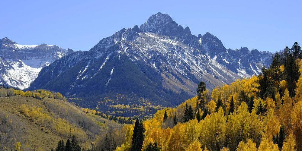
Mount Shavano and Tabeguache Peak
Sawatch Range • Salida, Colorado
Overview
Shavano and Tabeguache are the southernmost fourteeners in the Sawatch, a pair joined by a Class 2 ridge above Salida, and the standard day climbs Shavano first and adds Tabeguache across the saddle. The Angel of Shavano, the snow figure on Shavano's east face that melts into shape each spring, is visible from town. It is a long day, about 11 miles and 5,600 feet of cumulative gain with the return over Shavano, and the second climb of Shavano on the way home is what makes it.
Trail Highlights
The Route
From the Blank Cabin trailhead, the Mount Shavano trail follows the Colorado Trail for a short stretch, then turns uphill and climbs steadily through aspen and conifer. Above treeline near 11,800 feet the trail crosses open slopes toward the Angel's basin, then climbs a long grassy and rocky slope to the saddle south of Shavano's summit at about 13,400 feet. From the saddle a rocky trail climbs the final ridge to Shavano's summit at 14,229 feet.
For Tabeguache, descend Shavano's northwest ridge about 500 feet to the connecting saddle, then climb about 450 feet of talus up Tabeguache's east ridge to its summit at 14,155 feet. Return by the same ridge, re-climb Shavano, and descend the standard route. The old Jennings Creek route down Tabeguache's west side is closed and eroded; do not use it as a shortcut. The Colorado Fourteeners Initiative opened two new reroutes on the Shavano trail in August 2026 and closed the old braided line for restoration, so follow the new tread even where older maps and tracks disagree.
Getting to the Trailhead
From US 285 at Poncha Springs, follow Chaffee County Road 140 west and County Road 250 north to the Blank Cabin trailhead at about 9,750 feet, roughly 9 miles of gravel that passenger cars handle when dry. The lot fills on summer weekends and overflow parks along the road. No fee or permit. There is a vault toilet at the trailhead and dispersed camping nearby.
Best Time to Hike
Because the route faces east and starts relatively low, Shavano opens earlier than most Sawatch peaks: late June with microspikes for the snowfields, dry by mid-July, and good into early October. The Angel usually melts out by early July. Afternoon storms are the July and August pattern, and with two summits and a re-climb to make, the traverse needs a pre-dawn start and a hard turnaround time at Shavano's summit. In winter the standard route is a long snowshoe from the plowed county road.
Good to Know
Dogs are allowed on leash; the traverse is loose enough that many owners leave the dog at Shavano. Not a kid hike. Carry more water than a single peak needs, since there is none on the ridge and the second Shavano climb comes late in the day. Poles and a helmet earn their weight on the traverse. The Angel of Shavano campground on County Road 240 is the developed camping. Salida, 30 minutes east, has hot springs, restaurants, and lodging. The Mount Shavano guide covers the Shavano climb in detail, and the Tabeguache peak page has the traverse planning.
Sources
Figures and access details on this page were checked against these pages on 2026-09-04. Conditions change; confirm with the managing agency before you go.
Who to call
Conditions, closures, permits, and anything left behind on Mount Shavano and Tabeguache Peak.
- Managed by
- Salida Ranger District, Pike-San Isabel National Forests
(719) 539-3591 (Salida, Mon to Fri 8 to 4:30) · website - Lost and found, non-emergency
- Chaffee County Sheriff's Office
(719) 539-2596 · website - Emergency
- 911. Cell coverage is patchy on most of these trails; a text to 911 can get through where a call cannot.
Numbers checked 2026-10-04. Colorado United is an independent guide, not the land manager; wallets, keys, and dogs found on the trail go to the offices above.
What to Pack
Gear guides for this kind of hike:
Frequently Asked Questions
How long does the Mount Shavano and Tabeguache Peak take?
Most hikers finish the 11-mile route in about 10 hours, plus stops. Allow extra time at altitude and for photos.
How hard is the Mount Shavano and Tabeguache Peak?
It is rated hard, with 5,600 feet of gain over 11 miles and a high point of 14,229 feet. Come with conditioning and high-country experience.
Is the Mount Shavano and Tabeguache Peak dog-friendly?
Yes, leashed dogs are allowed. Pack water for them and clean up after them.
When is the best time to hike the Mount Shavano and Tabeguache Peak?
The best seasons are summer and fall. Start early to beat both the crowds and Colorado's afternoon thunderstorms.
Do I need a pass or permit for the Mount Shavano and Tabeguache Peak?
No pass or permit is required to park, though popular lots still fill early on summer weekends.
Planning a Colorado trip? Get our packing checklist.
Free PDF + a weekly note on the best trails for the current season.
We respect your inbox. Unsubscribe anytime.
Trail Information
Nearby Trails in Sawatch Range
Connected pages
- Hikes near Salida
All curated trails in the Salida area.
- Hiking in the Sawatch Range
Regional trail guide.
Discover More Trails
Browse our complete directory of Colorado hiking trails with detailed guides and filters.
View All Trails