Mount Sherman Hike: A Complete Guide to Colorado's Easiest 14er
Mount Sherman is the 14er most people pick for their first summit, and for good reason. It's 14,036 feet tall, sits between Fairplay and Leadville in the Mosquito Range, and asks for only about 5.25 miles of round-trip walking with roughly 2,100 feet of elevation gain. The trailhead starts high (near 12,000 feet), so you skip the long forest grind that makes peaks like Mount Elbert a sunrise-to-afternoon commitment. Most fit hikers are back at the car before lunch.
That short stat line is the whole appeal. Mount Sherman gives you a real Class 2 fourteener with old mining ruins, a broad summit ridge, and big Mosquito Range views, without technical climbing or a punishing approach. It's still a 14er, though. The upper ridge is exposed to wind and lightning, early-season snow lingers on the southwest slopes, and the trailhead road can stop a low car well short of the high lot.
This guide covers the route section by section, what to pack, how to time the weather, and the mistakes that turn an easy day into a hard one.
What You'll Learn
- Quick Stats: Mount Sherman at a glance
- Getting to the Mount Sherman Trailhead
- The Route, Section by Section
- The Mining Ruins You'll Pass
- What to Pack
- Mount Sherman Weather and Timing
- When to Hike Mount Sherman
- Is Mount Sherman Really the Easiest 14er?
- Adding Mount Sheridan and Gemini Peak
- Common Mistakes on Mount Sherman
- Frequently Asked Questions
Quick Stats: Mount Sherman at a glance
- Elevation: 14,036 ft
- Trailhead: Fourmile Creek (upper lot), near 12,000 ft
- Round Trip Distance: 5.25 miles (longer if you park at the lower 2WD lot)
- Elevation Gain: 2,100 ft
- Class: Class 2 (no technical climbing; a short rocky ridge near the top)
- Difficulty: The easiest standard 14er in Colorado, or close to it
- Time: 3.5 to 6 hours typical
- Best Season: Mid-June through September
- Permit: None required for day hiking
- Crowds: Heavy on summer weekends
The peak is named for General William Tecumseh Sherman. It anchors the southern Mosquito Range, with Mount Sheridan, Gemini Peak, and Dyer Mountain all within reach of the same saddle.

Getting to the Mount Sherman Trailhead
Mount Sherman has two standard approaches. The Fourmile Creek trailhead on the east (Fairplay) side is the popular one, and it's what this guide follows. The Iowa Gulch trailhead on the west (Leadville) side is shorter still but the access road is rougher and gated lower in many years.
From Fairplay (Fourmile Creek):
- From US-285 in Fairplay, turn west onto Fourmile Creek Road (County Road 18)
- Follow it about 12 miles toward the old Leavick townsite
- The road climbs steadily and gets rockier as you gain elevation
Here's the catch that trips people up: the road condition decides where your hike starts. A two-wheel-drive car can usually reach a lower parking area, but the final stretch to the upper trailhead near 12,000 feet wants high clearance and ideally 4WD. If you park at the lower 2WD lot, add roughly a mile each way and a few hundred feet of gain. Plenty of people walk the road; it just lengthens the day.
Parking: First-come, no fee. The upper lot is small and fills early on summer weekends. The road itself becomes the overflow.
Restrooms: None at the trailhead. Plan accordingly before you leave Fairplay.
Cell service: Unreliable at the trailhead, mostly absent above the saddle. Download your map offline in town.
The Route, Section by Section
The standard line is the Southwest Ridge from Fourmile Creek. It follows old mining roads most of the way, then a clear footpath to the summit. Navigation is easy in good visibility, harder in a whiteout because the upper ridge is broad.
Section 1: Trailhead to the Mining Basin (Miles 0 to 0.9)
From the upper trailhead, you walk an old road grade into a wide basin dotted with mine ruins. The grade is gentle here. You're already above treeline, so the views open immediately and the wind is a factor from the start. Take it easy; you're starting near 12,000 feet, and people who sprint this section pay for it higher up.
Section 2: The Climb to the Saddle (Miles 0.9 to 1.4)
The trail steepens as it switchbacks up toward the saddle between Mount Sheridan (to your south) and Mount Sherman (to your north). This is the first real work of the day. You'll pass the weathered timbers of the Hilltop and Dauntless mines along the way. Reach the saddle around 1.4 miles in, near 13,150 feet, and the wind usually announces itself here. It funnels through the gap.
Section 3: The Summit Ridge (Miles 1.4 to 2.6)
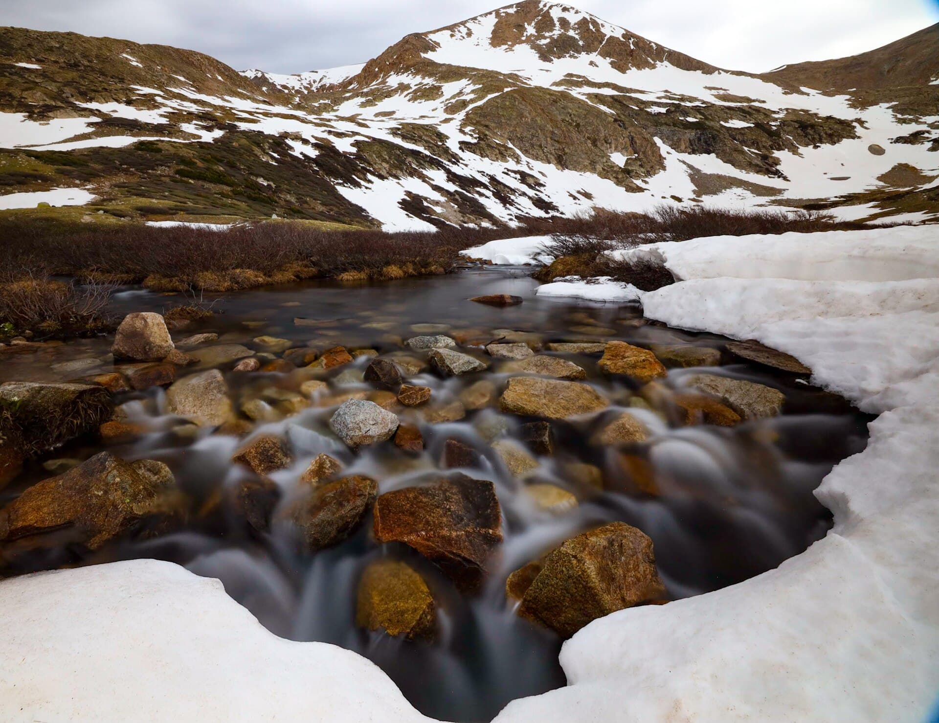
Turn north and follow the broad ridge toward the summit. This is the part that earns the Class 2 rating. The trail is rocky and the ridge narrows in spots, with a steeper drop on the east side. There's some easy boulder hopping near the top where you'll use hands for balance, but nothing technical and no real exposure that should worry a steady hiker. Cairns mark the way. In early season, a cornice can build on the east edge of this ridge, so stay on the rock and off the snow lip.
The summit is a broad, flat-topped area, big enough to spread out. On a clear day you can see Mount Elbert and Mount Massive to the west, the Sawatch spread out beyond, and South Park rolling away to the east.
Section 4: The Return (Miles 2.6 to 5.25)
Descend the same route. The ridge feels quicker going down, but loose rock makes a turned ankle the most common injury on this peak, so don't get sloppy. Below the saddle, the old road grade carries you back to the car. If you parked at the lower lot, the road walk at the end is the part everyone forgets to plan for.

The Mining Ruins You'll Pass
Mount Sherman sits in the heart of an old silver and lead district, and the route is lined with the bones of it. You'll walk past collapsed mine buildings, rusted machinery, ore-cart tracks, and the timber frames of the Hilltop Mine and the Dauntless Mine on the climb to the saddle. The Leavick townsite at the base of the road is what's left of a mining camp that ran here in the late 1800s.
It's tempting to poke around inside the structures. Don't. The wood is a century old and rotten, old mine shafts open into the ground without warning, and the timbers can give way. Photograph them from the trail and keep your footing on solid rock. These ruins are part of what makes Sherman feel different from a plain alpine slog; just treat them as scenery, not a playground.
What to Pack
Mount Sherman is short, which fools people into underpacking. The non-negotiables:
Water. 2 liters minimum. There's no reliable water to filter on the route, so carry what you'll drink. An insulated bottle keeps it from freezing on a cold early start.
Food. 600 to 1,000 calories of trail food. The hike is short, but altitude kills your appetite, so bring food you'll actually eat and snack every hour.
Layers. The summit can run 25 to 35°F colder than Fairplay, and the saddle wind makes it feel worse. Start with a base layer and light insulation; carry a wind shell and a warm layer for the ridge. See our base layers guide.
Rain shell. A waterproof rain jacket is required, not optional. The whole route is above treeline with zero shelter.
Sun protection. UV at 14,000 feet is brutal and the ridge has no shade at all. Sunglasses, sunscreen on every exposed inch, and a hat.
Headlamp. For the alpine start. A Petzl Actik Core or Black Diamond Spot 400 covers it.
Footwear. Sturdy boots or trail runners with real grip. The summit ridge is loose rock that punishes thin soles. See our hiking boots guide.
Wind protection for your hands and face. The saddle wind is the thing people remember. Light gloves and a buff make the ridge bearable.
Map and offline GPS. The broad upper ridge is genuinely confusing in fog. Pre-download the route on Gaia GPS or AllTrails.
Microspikes (shoulder season). Useful for lingering snow on the ridge in June and again after mid-September. See our microspikes guide.
Mount Sherman Weather and Timing
The one rule that matters most on Mount Sherman: be off the summit by noon.
The entire route is above treeline. Colorado's afternoon thunderstorms build between 11 AM and 2 PM in summer, and lightning above treeline is the leading cause of weather deaths on 14ers. On this peak there is nowhere to hide. The broad ridge that makes the hike easy also makes you the tallest thing around in a storm.
A workable timeline:
- Trailhead: 5 to 6 AM (earlier in July and August monsoon season)
- Saddle: about an hour in
- Summit: 8 to 9 AM
- Back below the saddle: by 10 to 11 AM
- Trailhead: late morning
Check a mountain forecast before you go. Mountain-forecast.com lists Mount Sherman directly, and forecast.weather.gov covers the Fairplay and Leadville area. Watch for:
- Storm probability above 30 percent: rethink the day
- Summit wind above 30 mph: the ridge becomes miserable and risky
- Summit highs below freezing: pack full winter layers even in summer
Sherman is notorious for wind specifically. The saddle and ridge catch it, and a calm parking lot can give way to a 40 mph blast up top. Wind, more than storms, is what turns most people around here.

When to Hike Mount Sherman
Best months: Mid-June through September.
June: Snow lingers on the southwest slopes and the summit ridge into mid-June most years. Microspikes help, and watch for a cornice on the east side of the ridge.
July: Prime season. Monsoon storms start mid-month and build earlier each afternoon, so start by 5 AM.
August: Peak monsoon. Storms are reliable by late morning. Hold the noon rule firmly.
September: Often the best weather of the year. Cooler, drier, fewer storms. Early snow possible after mid-month.
October: Doable early with the right gear; winter conditions take over by late month.
November through May: A winter mountaineering objective. The Fourmile road closes well below the trailhead, which turns this into a long snow approach with avalanche terrain on the slopes. Not a casual outing.
Is Mount Sherman Really the Easiest 14er?
It's the one most lists hand to beginners, and the numbers back it up. The combination of a high trailhead, short distance, modest gain, and Class 2 terrain with no exposure to speak of makes it the gentlest standard 14er in the state. Mount Bierstadt is the other usual answer, and the two are close. Bierstadt is longer (7 miles) but easier to drive to; Sherman is shorter but needs a rougher road. See our Mount Bierstadt guide to compare.
"Easiest 14er" still means a 14,000-foot mountain. Altitude doesn't care that the hike is short. If you've flown in from sea level, sleep a night or two in the mountains first, and read our altitude sickness guide before you go. For where Sherman lands against the rest of the beginner peaks, see our easiest 14ers ranking.
Adding Mount Sheridan and Gemini Peak
Strong hikers sometimes bag a neighbor from the same saddle. Mount Sheridan (13,748 ft) sits directly across the saddle to the south; it's a 13er, not a 14er, but it adds a short steep push and a different view for not much extra distance. Gemini Peak (13,951 ft) lies just north along the ridge past Sherman's summit and is the highest named 13er in Colorado. Dyer Mountain extends the ridge run further for the truly motivated.
None of these are necessary, and adding them stretches your time on exposed ridgeline, which raises your lightning risk. If you tack one on, start even earlier and watch the sky harder. For most people, Sherman alone is the day.
Common Mistakes on Mount Sherman
Underpacking because it's short. A 5-mile hike at 13,000-plus feet with no shelter is not a casual stroll. Bring the layers, water, and rain shell.
Starting late. "It's only 5 miles" lulls people into a 9 AM start, which puts them on the summit at storm time. Start early anyway.
Misjudging the road. Driving a low car too far up Fourmile Creek Road ends in a scrape or a stuck vehicle. Park where your clearance runs out and walk the rest.
Ignoring the wind. Sherman's saddle and ridge funnel wind hard. Pack gloves and a real wind shell even on a warm forecast.
Wandering on the ridge in fog. The broad summit ridge is easy to lose in clouds. Carry an offline GPS track and follow the cairns.
Exploring the mine ruins. Rotten timber and hidden shafts are a genuine hazard. Look, photograph, stay out.
Treating snow as harmless. Early and late season, the east side of the summit ridge can hold a cornice. Stay on rock.
Frequently Asked Questions
How long does it take to hike Mount Sherman?
Most hikers finish in 3.5 to 6 hours round trip from the upper Fourmile Creek trailhead, covering about 5.25 miles. Faster hikers do it in around three hours; add an hour or more if you park at the lower 2WD lot and walk the extra road.
How hard is Mount Sherman?
It's Class 2 and widely considered the easiest standard 14er in Colorado, with short distance and modest gain. The hard parts are altitude, wind on the exposed ridge, and loose rock near the summit. There's no technical climbing.
Can a 2WD car make it to the Mount Sherman trailhead?
Usually to a lower parking area, but not the upper trailhead near 12,000 feet. The final rough stretch wants high clearance and ideally 4WD. Parking lower adds about a mile each way of road walking.
What's the best time of year to climb Mount Sherman?
Mid-June through September. July and August bring afternoon monsoon storms, so start early and be off the summit by noon. September often has the calmest, driest weather of the season.
Is Mount Sherman a good first 14er?
Yes. The high trailhead, short route, and easy Class 2 terrain make it one of the best beginner 14ers, alongside Mount Bierstadt. Treat the altitude and weather seriously and it's an excellent introduction.
Final Thoughts
Mount Sherman earns its reputation as the easy 14er without being a walk in the park. The short, high route and old mining ruins make it one of the most approachable big summits in Colorado, but the exposed ridge, the wind, and the altitude still demand an early start and a full pack. Get the timing right and you'll be back at the car with a fourteener under your belt before most people have finished breakfast.
For the rest of your kit and your next summit, see our guides to hiking boots, rain jackets, and the easiest 14ers for beginners.
Get the Colorado 14er Packing Checklist (free PDF)
Plus a weekly note on the best Colorado trails, gear deals, and seasonal hike picks. No spam, unsubscribe anytime.
We respect your inbox. Unsubscribe anytime.