Black Canyon of the Gunnison: The Complete Colorado Visitor Guide
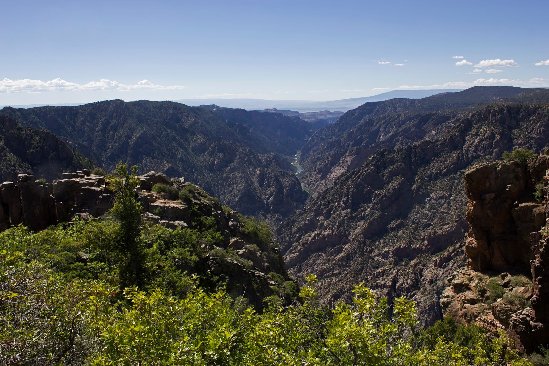
Black Canyon of the Gunnison is the steepest, narrowest, and one of the deepest canyons in Colorado. The walls plunge as much as 2,722 feet to the Gunnison River, and at the canyon's tightest point the rim sits a little over a thousand feet apart while the gorge below squeezes down to about 40 feet wide at the water. The Painted Wall, streaked with pink pegmatite, rises 2,250 feet from river to rim, which makes it the tallest sheer cliff in Colorado. This is the dramatic, vertigo-inducing park most Coloradans drive past on the way to somewhere else, and that's a mistake.
The reason it stays this dark and sheer is simple: the Gunnison River drops an average of 95 feet per mile through the park, one of the steepest river gradients in North America, and it has been cutting into hard Precambrian rock for around two million years. Sunlight reaches the bottom of the deepest sections for only a few minutes a day, which is how the canyon got its name. This guide covers how to get there, the South and North Rim drives, every rim trail worth your time, the brutal inner-canyon routes, fees, and when to go.

The South Rim overlooks put you right on the edge of a canyon that drops most of half a mile to the river.
Quick plan: Spend a half day on the South Rim Road hitting Gunnison Point, Chasm View, Painted Wall, and Sunset View, then add the Warner Point or Oak Flat trail if you want to stretch your legs. The full inner canyon is a separate, permit-only commitment.
New to high-elevation Colorado parks? Pair this with our Great Sand Dunes visitor guide, the Rocky Mountain National Park guide, and our Colorado hiking beginner's guide before you go.
What You'll Learn
- Quick stats at a glance
- Where it is and how to get there
- South Rim vs. North Rim
- The best hikes on the rim
- Hiking into the inner canyon
- Entrance fees and permits
- The best time to visit
- What to bring
- Frequently asked questions
Quick stats at a glance
- Location: Near Montrose, in western Colorado
- Deepest point: 2,722 feet (Warner Point)
- Narrowest point: about 40 feet wide at the river (The Narrows)
- Painted Wall: 2,250 feet, the tallest cliff in Colorado
- South Rim elevation: roughly 8,000 to 8,300 feet
- Entrance fee: $30 per vehicle, good for 7 days
- Established: national monument in 1933, national park in 1999
- Designation: International Dark Sky Park, so the stargazing is excellent
Where it is and how to get there
The park sits in western Colorado, and the developed South Rim entrance is about 15 miles east of Montrose on East Highway 50 and then north on CO-347. Montrose is the closest town with a full range of lodging, gas, and groceries, so most people base there.
Driving times to the South Rim:
- From Grand Junction: about 1.5 hours
- From Gunnison: about 1 hour
- From Denver: roughly 250 miles and 5 to 5.5 hours, usually over Monarch Pass on US-50
- From Durango: about 2.5 to 3 hours
If you're building a longer western Colorado loop, the park pairs naturally with Telluride and the San Juans to the south. Our weekend in Telluride hiking itinerary covers that side of the trip.
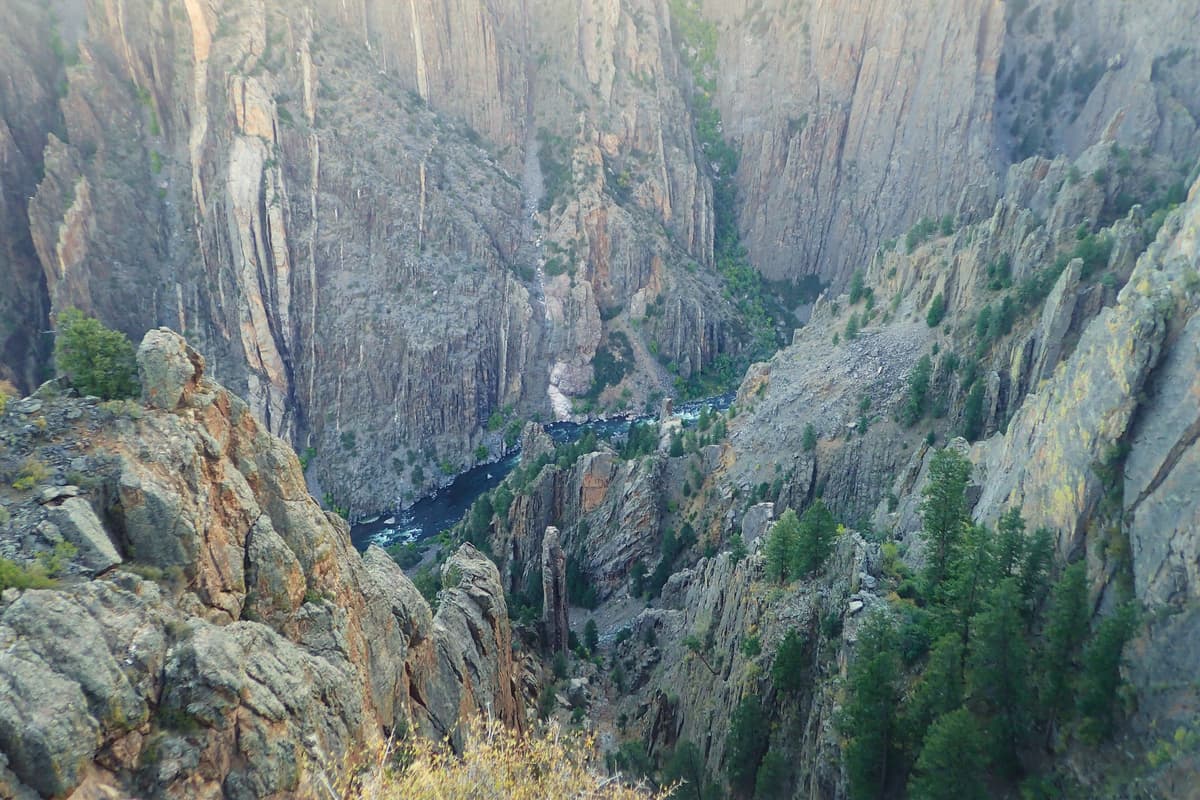
The Gunnison River drops about 95 feet per mile through the park, which is what carved walls this steep.
South Rim vs. North Rim
The two rims are only about 1,100 feet apart across the gap, but there's no bridge or road connecting them inside the park. Driving from one to the other takes two to three hours around through Montrose and Crawford, so pick one for a day trip.
The South Rim is the main event. It has the visitor center, the paved 7-mile South Rim Road, about a dozen overlooks, the campground, and all the easy rim trails. The road beyond Gunnison Point is plowed only to a point in winter and fully opens from early April into late November. If you have one day, this is where you go.
The North Rim is remote, quiet, and reached by a gravel road off CO-92 near Crawford. It has its own small campground, a ranger station, and some of the most heart-stopping straight-down overlooks in the park, including the view of the Painted Wall from across the gorge. The North Rim Road closes in winter. Serious rock climbers and people who want solitude come here; first-time visitors almost always stick to the South Rim.
The best hikes on the rim
Most visitors hike the rim, and you don't need a permit for any of these. They range from flat strolls to one genuinely steep loop. None of them reach the river.
Rim Rock Nature Trail (about 1 mile round trip) is an easy out-and-back from the campground that follows the canyon edge with steady views. Good for a first taste or an after-dinner walk.
Cedar Point Nature Trail (about 0.7 mile round trip) is a short, flat interpretive path off the South Rim Road that ends at two overlooks with big open views of the inner gorge and the Painted Wall. This is the best views-per-effort trail in the park.
Warner Point Nature Trail (about 1.5 miles round trip) starts at High Point at the very end of the South Rim Road. It climbs and dips through pinyon and juniper to Warner Point, which looks down at the deepest part of the canyon and west toward the San Juans and the Uncompahgre Valley. Save this one for late afternoon light.
Oak Flat Loop Trail (about 2 miles) is the one rim trail that actually drops below the rim, descending a few hundred feet into the upper canyon on a narrow, rooty path with a couple of steep, loose sections. It's the closest thing to inner-canyon terrain without a permit, and it's noticeably more strenuous than the nature trails. Wear real shoes and take it slow on the way back up at 8,000 feet.
On the North Rim, the Chasm View Nature Trail (about 0.3 mile) delivers a short walk to a dizzying overlook directly across from the Painted Wall.
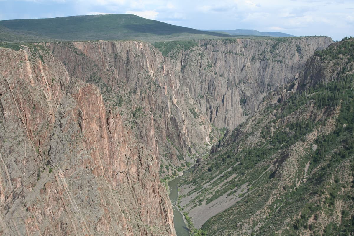
The Painted Wall rises 2,250 feet from the river. The pink streaks are pegmatite squeezed into the dark gneiss and schist.
Hiking into the inner canyon
Getting to the Gunnison River from the rim is not a maintained hike. There are no official trails into the inner canyon, only unmarked, unmaintained "wilderness routes" that drop 1,800 to 2,700 feet over roughly a mile. They are steep, loose, and physically demanding, and the park rates them for fit, experienced hikers only. People get hurt down here every year, and chest-high poison ivy lines most of the routes in summer.
The South Rim routes, each requiring a wilderness permit with a daily quota, are:
- Gunnison Route: the most popular and the one rangers point first-timers to. It's about a mile down but drops roughly 1,800 feet, including an 80-foot stretch where you pull yourself down a fixed chain. Plan on it being harder coming out than going in.
- Tomichi Route: shorter, steeper, and looser than the Gunnison Route, with a punishing scree gully. For strong scramblers.
- Warner Route: the longest and least steep grade, but it descends about 2,700 feet and is usually done as an overnight backpack.
If you want the river without the rock scrambling, drive the East Portal Road, a paved road with a steep 16% grade that switchbacks down to the Gunnison River at the bottom of the canyon near Crystal Dam. The river here is Gold Medal trout water, popular with fly anglers, and there's a small campground and a picnic area at the bottom. The road is too steep for vehicles or trailers over 22 feet and closes in winter.
Entrance fees and permits
The entrance fee is $30 per private vehicle, valid for 7 days, and it covers everyone in the car. Motorcycles are $25 and individuals on foot or bike are $15. An America the Beautiful annual pass ($80) gets you in free and is worth it if you're hitting multiple national parks in a year. Note that a separate non-resident annual pass was introduced for 2026, so check the current options on the official site before you buy.
Inner-canyon wilderness permits are required for both day hikes and overnight trips on the South Rim routes between May and October, and they carry daily quotas. The permit runs $6 plus $4 per person, and you reserve it on recreation.gov. Outside that window and on the North Rim, permits are often available first-come at the visitor center or ranger station, but call ahead. Rim hiking, the scenic drives, and the overlooks never require a permit.
Always confirm current fees, road status, and permit rules on the official National Park Service Black Canyon page before your trip, since they change.
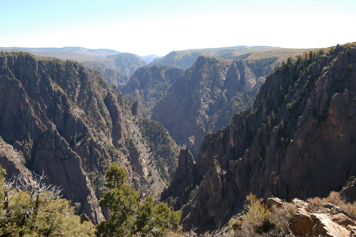
Afternoon light brings out the texture in the canyon walls. Mornings are better for photographing the shadowed depths.
The best time to visit
Late spring through early fall (May to September) is peak season, with both rims open, all trails accessible, and the visitor center fully staffed. Summer days on the rim are warm and pleasant at 8,000 feet, but the inner canyon bakes and afternoon thunderstorms roll in, so start early. The summer crowd is modest by national park standards, often 50,000 visitors in a peak month, a fraction of what Rocky Mountain National Park sees.
Fall (late September into October) is arguably the best window. The crowds thin out, daytime temperatures are comfortable, and the scrub oak and aspen add color to the rims. Visitor numbers can drop to 15,000 to 25,000 a month in the shoulder seasons.
Winter is quiet and stark. The South Rim Road is plowed only to a point, the North Rim Road and East Portal Road close, and you can snowshoe or ski the rim in solitude, but most services shut down. The park's Dark Sky designation makes any clear, moonless night a strong reason to stay after dark in any season.
Remember that the South Rim sits above 8,000 feet, so if you're coming from sea level, give yourself a day to adjust and read up on altitude sickness and how to prevent it before you hike hard.
What to bring
The rim is exposed and the inner canyon is no place to be underprepared. A few things worth packing:
- Sturdy footwear. Even the rim trails are rocky, and the inner-canyon routes demand grippy, broken-in hiking boots. See our picks for the best hiking boots for Colorado.
- Sun protection. The high, thin air burns fast. Pack a hat, sunglasses, and sunscreen.
- More water than you think. There's no water on the rim trails and none you'd want to carry up from the river, so bring a full hydration pack.
- Trekking poles for the Oak Flat descent and especially the inner-canyon routes. A pair of trekking poles saves your knees on the steep climb out.
- A headlamp if you plan to stargaze or come off the rim near dusk. A small headlamp weighs nothing and keeps you safe near the edge after dark.
Inner-canyon hikers should add long pants to deal with the poison ivy, a water filter for refilling at the river, and a clear plan to be back on the rim before the afternoon heat.
Frequently asked questions
How deep is the Black Canyon of the Gunnison?
The canyon reaches its deepest at Warner Point, where the rim sits 2,722 feet above the Gunnison River. The Painted Wall, the tallest cliff in Colorado, rises 2,250 feet straight up from the water. These steep, narrow walls are what make the canyon feel so dramatic from the overlooks.
Can you drive through Black Canyon of the Gunnison?
You can't drive through or across the canyon, but you can drive the paved 7-mile South Rim Road past about a dozen overlooks, which takes 2 to 3 hours with stops. A separate East Portal Road switchbacks down to the river on a steep 16% grade. The South and North Rims are not connected by any road inside the park.
Do you need a permit to hike Black Canyon of the Gunnison?
No permit is needed for the rim trails, the scenic drives, or the overlooks. You do need a wilderness permit, with a daily quota, to hike any of the inner-canyon routes down to the Gunnison River between May and October. Permits cost $6 plus $4 per person on recreation.gov.
Is Black Canyon worth visiting?
Yes. It's one of the most striking canyons in North America and one of Colorado's least-crowded national parks. A half day on the South Rim is enough to see the signature views, and the Dark Sky designation makes it a standout for stargazing. It's an easy add-on to a western Colorado or San Juan road trip.
How long do you need at Black Canyon of the Gunnison?
A half day covers the South Rim drive and a short rim trail or two. A full day lets you add Warner Point, Oak Flat Loop, and the East Portal Road to the river. Hiking an inner-canyon route to the Gunnison River is a strenuous all-day or overnight commitment that needs a permit.
Black Canyon rewards a slower pace: stand at a few overlooks long enough to watch the light move down the walls, then save energy for the climb out if you head below the rim. For more western Colorado ideas, see our roundup of the best Colorado hiking trails.
Get the Colorado 14er Packing Checklist (free PDF)
Plus a weekly note on the best Colorado trails, gear deals, and seasonal hike picks. No spam, unsubscribe anytime.
We respect your inbox. Unsubscribe anytime.