Fish Creek Falls Trail
Park Range • Steamboat Springs, Colorado
Overview
Fish Creek Falls is the 280-foot waterfall 4 miles from downtown Steamboat Springs, the town's postcard, and the walk to it is a quarter mile to an overlook and a short descent to the bridge at its base, 1 mile round trip. The upper falls trail continues 2.5 miles and 1,400 feet to a second waterfall for anyone who wants the hike as well as the view.
Trail Highlights
The Route
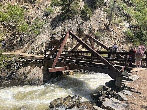
From the Forest Service lot, a paved, level path leads a quarter mile to an overlook with the falls in full view across the gorge; this section is wheelchair and stroller accessible. The main trail drops from the lot through aspen and cottonwood to the historic bridge below the falls, where the spray reaches you in June, with rock steps and a couple of short steep pitches.
Across the bridge the trail climbs the far side of the gorge on switchbacks and continues up Fish Creek through the forest, steeper and rockier, for 2.5 miles to the upper falls at about 8,700 feet, a smaller cascade in a quieter setting. The trail goes on to Long Lake and the Continental Divide for a much longer day. Most people turn around at the bridge for the 1-mile version. Every year from April 1 until about July 1 the Forest Service closes the footbridge and the 4 miles of trail beyond it while high water runs against the bridge's scoured abutments; the overlook and the walk down to the bridge stay open, but the upper falls do not.
Getting to the Trailhead
From Lincoln Avenue in downtown Steamboat, take 3rd Street north, turn right on Fish Creek Falls Road, and follow it 4 miles east to the Forest Service lot at the end. The lot charges a $5 day-use fee per vehicle, payable by card or cash at the machine, and fills by mid-morning from June through September; the overflow lot below adds a short walk, and the town bus stops at the bottom of the road in summer. The site is open 6 AM to 10 PM. Toilets at the lot.
Best Time to Hike
The falls are loudest in late May and June with the snowmelt and shrink to a ribbon by September. The aspen in the gorge turn in the third and fourth weeks of September, when the lot is as full as in July. Summer afternoons bring storms, but the lower trail is short and in the trees. In winter the falls freeze into an ice climb, the lower trail is packed and icy, and microspikes make it an easy walk; the upper trail is snowbound.
Good to Know
Dogs are allowed on leash. The overlook path is the most accessible walk in Steamboat, and the bridge is fine for any child who can manage rock steps. The rocks by the creek are wet and slick and the creek is fast in June; the Forest Service has pulled people out of it. Carry water. The upper trail is a real hike and needs shoes and a couple of liters. Steamboat is 10 minutes away with everything, and the Steamboat Springs hikes page lists the Spring Creek and Emerald Mountain trails in town.
Sources
Figures and access details on this page were checked against these pages on 2026-09-04. Conditions change; confirm with the managing agency before you go.
Who to call
Conditions, closures, permits, and anything left behind on Fish Creek Falls Trail.
- Managed by
- Hahns Peak/Bears Ears Ranger District, Medicine Bow-Routt National Forests
(970) 870-2299 (Steamboat Springs) · website - Lost and found, non-emergency
- Routt County Sheriff's Office
(970) 870-5563 (lost and found), non-emergency (970) 879-1090 · websiteFound property goes through the Property and Evidence Division. - Emergency
- 911. Cell coverage is patchy on most of these trails; a text to 911 can get through where a call cannot.
Numbers checked 2026-10-04. Colorado United is an independent guide, not the land manager; wallets, keys, and dogs found on the trail go to the offices above.
What to Pack
Gear guides for this kind of hike:
Frequently Asked Questions
How long does the Fish Creek Falls Trail take?
Most hikers finish the 1-mile route in about 1 hour, plus stops. Allow extra time at altitude and for photos.
How hard is the Fish Creek Falls Trail?
It is rated easy, with 250 feet of gain over 1 miles and a high point of 7,300 feet. It suits most hikers in reasonable shape.
Is the Fish Creek Falls Trail dog-friendly?
Yes, leashed dogs are allowed. Pack water for them and clean up after them.
When is the best time to hike the Fish Creek Falls Trail?
The best seasons are spring, summer, and fall. Start early to beat both the crowds and Colorado's afternoon thunderstorms.
Do I need a pass or permit for the Fish Creek Falls Trail?
No pass or permit is required to park, though popular lots still fill early on summer weekends.
Planning a Colorado trip? Get our packing checklist.
Free PDF + a weekly note on the best trails for the current season.
We respect your inbox. Unsubscribe anytime.
Trail Information
Nearby Trails in Park Range
Connected pages
- Hikes near Steamboat Springs
All curated trails in the Steamboat Springs area.
- Hiking in the Park Range
Regional trail guide.
Discover More Trails
Browse our complete directory of Colorado hiking trails with detailed guides and filters.
View All Trails