Blue Lakes Trail, Colorado: Complete Guide to All Three Lakes (2026)
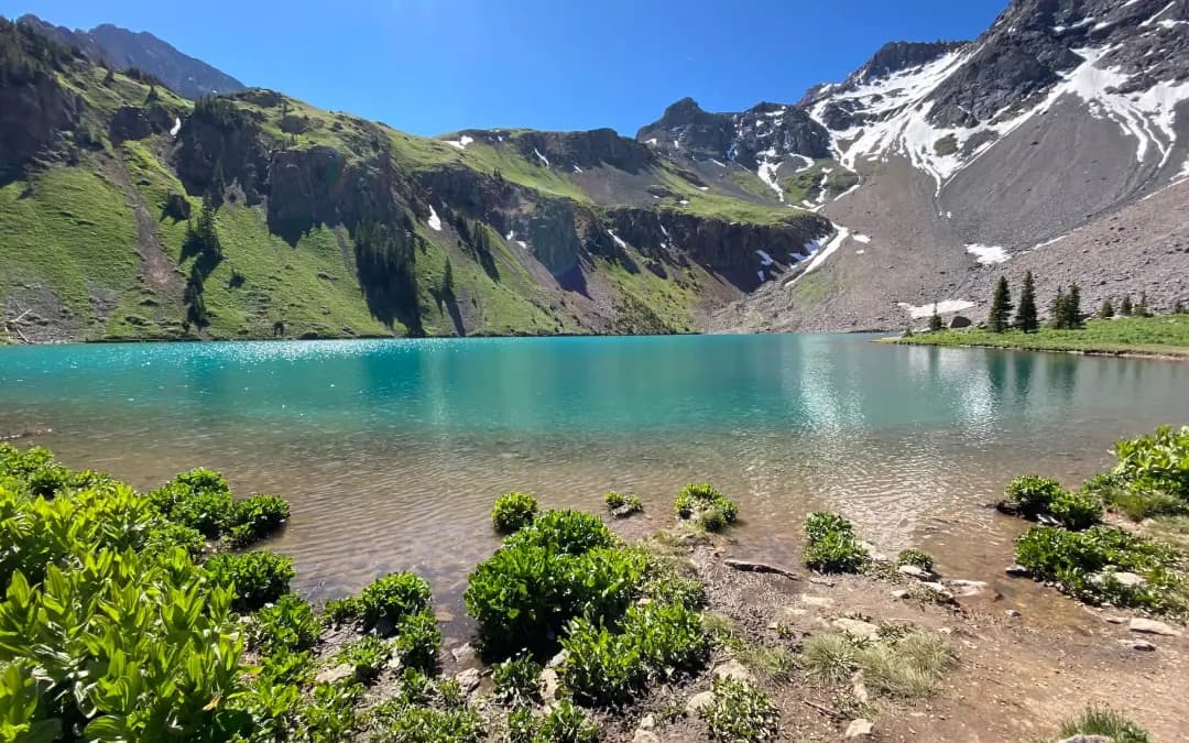
The Blue Lakes Trail is the hike people show their out-of-state friends when they want to prove Colorado is as good as the postcards. Three glacial lakes stacked up a hanging valley in the Mt. Sneffels Wilderness, each a different shade of turquoise, with 14,150-foot Mount Sneffels behind them. If you've seen a "Colorado alpine lake" photo on Instagram in the last decade, there's a decent chance it was Lower Blue.
Here's the catch. This isn't a beginner trail, and it isn't a secret anymore. The dirt road to the trailhead chews up low-clearance cars, the parking lot fills before sunrise on summer weekends, and the climb above Lower Blue turns into a grunt up loose switchbacks. The reward is real, but you need a plan.
This guide walks the trail mile by mile, including the option to push past Lower Blue to Middle, Upper, and Blue Lakes Pass, where ambitious hikers connect to the standard Mt. Sneffels route.
What you'll learn
- Quick stats for every section of the trail
- Getting to the trailhead and the truth about the road
- Lower Blue Lake mile by mile
- Middle and Upper Blue Lakes
- Blue Lakes Pass and the Mt. Sneffels connection
- Best time to hike and what each season looks like
- What to pack for the San Juans
- Wildlife and wilderness rules
- Where to stay nearby
- FAQs
Quick stats {#quick-stats}
| Detail | Lower Blue Lake | All three lakes | Blue Lakes Pass |
|---|---|---|---|
| Distance (RT) | 6.2 miles | 7.5 to 8.5 miles | ~10 miles |
| Elevation gain | ~1,600 ft | ~2,100 ft | ~3,600 ft |
| High point | 11,000 ft | 11,700 ft | 13,000 ft |
| Difficulty | Moderate | Moderate to hard | Strenuous |
| Type | Out and back | Out and back | Out and back |
| Season | Late June to early October | July to September | Mid-July to mid-September |
| Permits | None for day hiking | None for day hiking | None |
| Dogs | On leash only | On leash only | On leash only |
Trailhead elevation: about 9,400 feet. The trail sits inside the Mt. Sneffels Wilderness in Uncompahgre National Forest, Ouray County.
Getting to the trailhead {#getting-there}
The Blue Lakes trailhead is at the end of Forest Road 851, also called East Dallas Creek Road. From Ridgway, head west on Colorado 62 for about 5 miles, then turn left onto County Road 7. Follow it roughly 9 more miles to the trailhead. Total drive from Ridgway is 30 to 40 minutes.
The road is dirt after you leave the highway. The first several miles are fine for any car. The last 2 to 3 miles get washboarded and rocky. A passenger sedan can usually make it in dry conditions, but high clearance is honestly the right tool. After rain, the ruts deepen fast.
Parking is a single dirt lot that holds 30 to 40 vehicles. On July and August weekends, it fills before 7 AM, sometimes before 6. Overflow parking spills along the road shoulder, but rangers ticket vehicles blocking the turnaround or parked in vegetation. Roll in at 9 AM on a Saturday in wildflower season and plan to walk an extra mile from wherever you find a legal spot.
There is a pit toilet at the trailhead. No water, no trash service. Pack out everything. If the lot is jammed, Tuesday through Thursday is dramatically quieter, even in peak season.
The trail to Lower Blue Lake {#lower-blue-lake}
From the trailhead, the path climbs gently for the first half mile through aspen and spruce along East Dallas Creek. You'll cross the wilderness boundary sign shortly after starting.
The next mile and a half stays mellow as the trail traces the creek through mixed forest. Footing is good, grade is forgiving. Mid-July through August, the understory fills in with paintbrush, columbine, and fireweed in open sections.
Around mile 2, the trail steepens and starts switchbacking up a forested hillside. This is the section that catches people off guard. The grade pitches up, the air thins, the rocks get loose. You'll gain roughly 800 feet over the next mile.
The reward comes fast. Around mile 3, the trees give way to a meadow and Lower Blue Lake appears below the trail. The water sits in a glacier-carved bowl with vertical rock walls on three sides. The color is genuinely teal in good light, not the filter version. Mount Sneffels and Dallas Peak rise behind it.
There's space to spread out along the bench above the lake. Most day hikers turn around here. If you only have the legs for one lake, this is it. Treat any water from creek crossings; carry enough that you don't depend on it.
Pushing on to Middle and Upper Blue Lakes {#middle-and-upper}
From Lower Blue, the trail climbs hard. You'll gain 500 feet in roughly half a mile up a rocky slope above the outlet. A stream crossing runs strong in early summer and tame by August. Footing is loose; trekking poles save knees on the way down.
Middle Blue Lake sits at about 11,500 feet, smaller and deeper than Lower. The water reads cobalt rather than teal. You're above tree line now and fully exposed.
A short, easier push gets you to Upper Blue Lake at about 11,700 feet. Upper is the smallest and most stark. No trees, just rock, snowmelt, and the south face of Sneffels. If you make it here, you've covered roughly 8.5 miles round trip with 2,100 feet of total gain.
This is the turnaround for most hikers doing all three. Eat lunch above Upper Blue and head down with daylight to spare. Afternoon thunderstorms in July and August are near-certain.
Pushing to Blue Lakes Pass {#blue-lakes-pass}
Blue Lakes Pass sits at 13,000 feet, perched between Mt. Sneffels and Dallas Peak. Getting there from Upper Blue means another 1,300 feet of vertical over rough, steep terrain. The trail climbs talus and scree, with sections picked out cairn by cairn.
The reward is one of the most photographed views in the San Juans. You're standing in a notch with Yankee Boy Basin dropping away to the south and the Blue Lakes basin behind you to the north. Mount Sneffels is right there, and the standard route up its south face peels off the pass.
Most Sneffels climbers approach from Yankee Boy Basin on the south side, where the road gets you to about 12,500 feet. Coming from Blue Lakes is the long way but the prettier way. Strong hikers can do it as a single push: trailhead, all three lakes, pass, summit, back. Roughly 12 miles with 5,000 feet of gain, all above 9,400 feet. See the Mount Sneffels route guide before you commit.
Most hikers should treat Blue Lakes Pass as the endpoint and skip the summit unless they have peak-bagging experience, an early start, and a stable weather window.
When to go {#when-to-go}
Late June. Snow still melts off the upper switchbacks. Road usually opens by mid-June, but trail above Lower Blue often holds patches into early July. Crossings run high and cold.
Mid-July through early August. Peak wildflowers and peak crowds. Paintbrush, columbine, fireweed, and larkspur bloom in waves. Get to the lot by 6 AM on weekends.
Late August. Wildflowers fade, trail thins out, lakes settle into their deepest color. Solid window if you want views without the parking scramble.
Early to mid-September. Aspens turn gold, fireweed goes red. My pick if you can only go once. Bring layers; afternoon storms still pop.
Late September through early October. Snow becomes likely up high. Road gets muddy. Doable but watch forecasts.
Mid-October through May. Road closes seasonally and the trail is buried. Backcountry ski or snowshoe objective for people who know what they're doing.
What to bring {#what-to-bring}
Pack this like the high-country hike it is.
- Footwear. Sturdy hiking boots or trail runners with real tread. The switchbacks above Lower Blue are loose and crossings can be slick. See our hiking boots for Colorado guide.
- Trekking poles. Strongly recommended for the descent off Lower Blue. Picks in our trekking poles roundup.
- Water. Three liters minimum for Lower Blue round trip, four if pushing to Upper. A hydration pack makes it easier to sip on the climb. Filter water from creeks.
- Layers and a rain shell. Mornings start in the 40s even in July. Afternoon storms July through September are routine.
- Sun protection. Sunscreen, hat, sunglasses. You're at 11,000 feet for hours.
- Acclimatize. Coming from sea level, give yourself two days at Ridgway or Ouray elevation first. Read our altitude sickness guide.
- Backpackers. Bears pass through this drainage. Carry a bear-resistant container. See our bear canister guide.
Wildlife and wilderness etiquette {#wilderness-etiquette}
The Mt. Sneffels Wilderness is federally designated, which means tighter rules than a regular national forest trail. Plan around them or risk a fine.
- Dogs on leash at all times. Off-leash dogs are the number one citation rangers write here. The 6-foot rule applies even if your dog has perfect recall.
- No drones. Wilderness areas prohibit motorized and mechanized equipment.
- No campfires above 10,400 feet. That includes the entire Blue Lakes basin. Use a stove.
- Group size limit is 15 combined people and stock.
- No bikes or wheeled carts.
- Pack out all trash, including biodegradables like apple cores and orange peels. They don't decompose at this altitude on any reasonable timeline.
- Pack out dog waste. Don't bag it and leave it for "later."
- Camp 100 feet from water. Backpackers can camp in the basin but not lakeside.
Expect yellow-bellied marmots whistling from the talus, pikas squeaking out of rock piles, mountain goats high on the ridges, and occasional deer or elk in the lower forest. Black bears live in the area but are uncommon at the lakes. Give wildlife room and never feed anything, including the begging marmots.
Where to stay nearby {#where-to-stay}
Ridgway is the closest town and the most relaxed option. Small working town, a couple of solid hotels, a state park campground, and a 30-minute drive to the trailhead. The True Grit Cafe handles the post-hike beer and burger.
Ouray sits 10 miles south of Ridgway with more restaurants, more hotels, the famous hot springs, and easy access to other San Juan trails. Use Ouray as a base if you're doing multiple hikes in the area. Our Ouray hiking guide covers nearby options.
Telluride is an hour west over Dallas Divide. The splurge base. Fine if you're stringing Blue Lakes together with Telluride-area trails.
Ridgway State Park campground books months ahead for summer weekends. Dispersed camping is allowed along sections of East Dallas Creek Road below the wilderness boundary.
FAQs {#faqs}
How hard is the Blue Lakes Trail?
Lower Blue is moderate: 6.2 miles round trip with 1,600 feet of gain. Reasonably fit hikers do it in 4 to 6 hours. All three lakes pushes into moderate-to-hard at 8.5 miles and 2,100 feet of gain. Blue Lakes Pass is strenuous at 10 miles, 3,600 feet of gain, and serious altitude.
Do you need a permit for Blue Lakes?
No permit is required for day hiking or backcountry camping. Wilderness rules apply, but there's no quota system or fee. Check the Uncompahgre National Forest site before your trip in case that changes.
Are dogs allowed on the Blue Lakes Trail?
Yes, on a 6-foot leash at all times. Off-leash dogs are the most common violation rangers cite here. The loose rock and stream crossings can be hard on dogs, and altitude affects them too.
Can you swim in the Blue Lakes?
Legally yes, but the water is glacier-fed and stays in the 40s through summer. A quick plunge is doable on a hot afternoon. Anything longer than a minute or two and you'll regret it.
How long does the Blue Lakes hike take?
Plan on 4 to 6 hours for Lower Blue round trip with breaks. All three lakes runs 6 to 8 hours. Adding Blue Lakes Pass pushes you to a full day at 8 to 10 hours. Start by 7 AM in summer to be off the upper trail before afternoon thunderstorms.
Is the road to the trailhead 4WD only?
No, but high-clearance helps a lot. The first several miles are fine for any vehicle. The last 2 to 3 miles get rough with washboard and embedded rocks. A patient driver in a sedan can make it in dry conditions. After rain, the ruts get serious.
Final word
Blue Lakes earns its reputation. The view from Lower Blue is one of the best lake-and-mountain shots in Colorado, and pushing on to Upper Blue or the pass gives you experiences most casual visitors never see. Respect the altitude, get to the trailhead early, follow the wilderness rules, and bring enough water. The San Juans are not the place to wing it. Pack carefully, start early, and the trail will pay you back.
Get the Colorado 14er Packing Checklist (free PDF)
Plus a weekly note on the best Colorado trails, gear deals, and seasonal hike picks. No spam, unsubscribe anytime.
We respect your inbox. Unsubscribe anytime.