10 Best Hikes Near Telluride, Colorado (2026 Trail Guide)
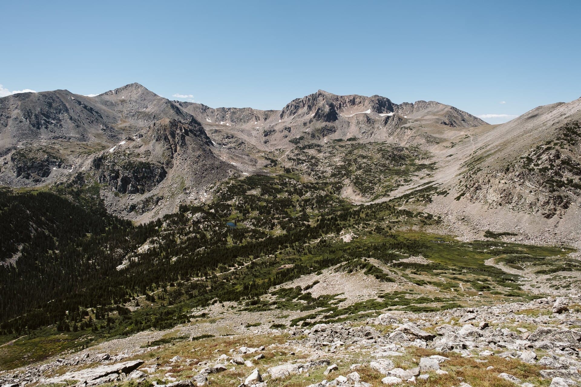
Telluride sits at 8,750 feet in a box canyon carved by the San Miguel River, hemmed in on three sides by 13,000-foot peaks in the San Juan Mountains. That geography means you can walk from the main street to a trailhead in five minutes and be standing next to Colorado's tallest free-falling waterfall within the hour. Whether you're looking for a flat riverside stroll or a scramble up a 14er, Telluride's trail network punches well above its weight for a town of 2,500 people.
What You'll Learn
- Bear Creek Trail
- Bridal Veil Falls Trail
- Blue Lake Trail
- Jud Wiebe Memorial Trail
- Telluride River Trail
- Sneffels Highline Trail
- Hope Lake Trail
- Wasatch Trail
- Bear Creek Canyon Preserve Loop
- Wilson Peak
Bear Creek Trail
Bear Creek Trail is Telluride's signature day hike, and for good reason. The trailhead starts right at the south end of Pine Street, so you don't even need to drive. You'll climb steadily through aspen groves and old-growth spruce, gaining about 1,040 feet over 2.4 miles (one way) before reaching the 80-foot cascade of Bear Creek Falls.
The trail follows the creek through the Uncompahgre National Forest and the 325-acre Bear Creek Preserve. It's well-maintained and easy to follow, though it does get narrow in spots with some exposure on the canyon walls. You'll want sturdy hiking boots for the rockier sections near the falls.
Trail stats: 4.8 miles round-trip, 1,040 ft elevation gain, moderate difficulty. Allow 2 to 3 hours.
Most hikers turn around at the falls viewpoint, but you can continue past the falls for another mile to reach a high meadow with wildflowers from late June through August. The trail gets less crowded beyond the falls, and the views back down the canyon toward town are spectacular.
Bridal Veil Falls Trail
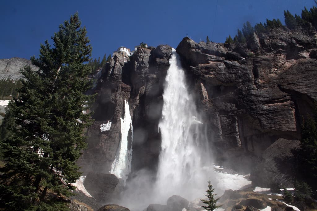
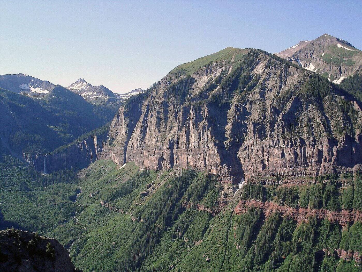
Bridal Veil Falls drops 365 feet, making it Colorado's tallest free-falling waterfall. The trail to the base is surprisingly easy, following the old mining road along the San Miguel River from the east end of Colorado Avenue. It's 1.8 miles one way with gentle elevation gain, making it accessible for families and casual walkers.
The falls are most impressive in late May and June when snowmelt is peaking. By late August, the flow drops considerably. At the top of the falls sits the historic Smuggler-Union Hydroelectric Power Plant, built in 1907, which still generates roughly 40% of Telluride's electricity.
If you want to get to the top of the falls, you can drive or hike the steep switchback road (4WD recommended for driving). The upper parking lot gives you access to Blue Lake Trail and the Bridal Veil Basin, which is worth the extra effort if you've got the legs for it.
Trail stats: 3.6 miles round-trip to the base, 540 ft elevation gain, easy to moderate. Allow 1.5 to 2 hours.
Pack a quality water filter if you're planning to extend past the falls and into the upper basin. Creek crossings are common up there, and it's smart to have a reliable way to refill.
Blue Lake Trail
Blue Lake is Telluride's crown jewel for alpine scenery. The trailhead starts at the Bridal Veil Falls Power Station (you can drive up the switchbacks, though the road is narrow and a little nerve-wracking for first-timers). From the power station, you'll hike through the historic Bridal Veil Basin, passing old mining ruins and gaining elevation steadily into a high alpine cirque.
The lake itself sits at 12,000 feet, shimmering beneath steep rock walls. It's the kind of place that makes you forget you drove to Colorado and not Nepal. The water is clear, cold, and stunningly blue against the grey talus.
Trail stats: 5.2 miles round-trip from the upper trailhead (8.8 miles if you start from town), 2,500 ft total elevation gain, strenuous. Allow 4 to 6 hours.
You'll be above treeline for most of this hike, so bring layers and a packable rain jacket. Afternoon thunderstorms are nearly guaranteed from mid-June through August. Start early and plan to be off the exposed ridgeline by noon. This trail isn't recommended before late June due to heavy snow. Check conditions with the Telluride Visitor Center before heading out.
Jud Wiebe Memorial Trail
If you've got two hours and want the best bang for your effort, Jud Wiebe is it. This 3-mile loop starts from the north end of Aspen Street and climbs through dense aspen forest to a ridge with panoramic views of town, the box canyon, Bridal Veil Falls, and the surrounding peaks.
The trail gains about 1,300 feet, so it's not a walk in the park, but it's short enough that most hikers can handle it. You'll be breathing hard at 9,000+ feet if you haven't acclimatized, so take your time and bring plenty of water.
This is a perfect early-morning hike before the town gets busy. The east-facing ridge catches great light at sunrise, and you'll beat the afternoon heat. It's also one of the best fall foliage hikes in the area when the aspens turn gold in late September.
Trail stats: 3.0-mile loop, 1,300 ft elevation gain, moderate. Allow 1.5 to 2.5 hours.
Telluride River Trail
The River Trail is Telluride's flattest and most accessible hike, running 2.6 miles along the San Miguel River from Town Park to the Bridal Veil Falls trailhead. It's paved for much of the way and passes Beaver Pond and the Kids' Fishing Pond, making it ideal for families with young children or anyone who wants a mellow walk with mountain views.
You don't need hiking poles for this one, but you might want them for the return trip if you continue past the paved section toward Bridal Veil. The unpaved stretch gets rocky and uneven in spots.
Trail stats: 5.2 miles round-trip, 360 ft elevation gain, easy. Allow 1.5 to 2 hours.
The River Trail connects to several other trails, so you can use it as a warm-up before tackling Bear Creek or Bridal Veil. There are benches along the way and plenty of spots to sit by the river and watch for trout.
Sneffels Highline Trail
This is the hike for experienced hikers who want a full-day adventure. The Sneffels Highline traverses high ridges between Telluride and the Mount Sneffels Wilderness, with views that stretch from the Wilson Group to the Sneffels Range. You'll stay above 11,000 feet for most of the route, crossing alpine meadows, rocky passes, and wildflower-covered slopes.
The standard route runs from the top of Telluride's free gondola (which gets you to 10,535 feet without breaking a sweat) to the Deep Creek trailhead. You'll need to arrange a car shuttle or hitchhike back, which is common and easy in the Telluride area during summer.
Trail stats: 12.4 miles point-to-point, 2,800 ft elevation gain (with several ups and downs), strenuous. Allow 7 to 9 hours.
Bring a reliable GPS device or download offline maps. The trail isn't always well-marked above treeline, and fog can roll in fast. This trail is best from mid-July through mid-September when the snowfields have melted. Check with the US Forest Service Norwood Ranger District for current conditions.
Hope Lake Trail
Hope Lake sits in a beautiful alpine basin below the Wilson Group, about 20 minutes south of Telluride near Trout Lake. The drive to the trailhead on Highway 145 is scenic on its own, passing through the Lizard Head Pass area with views of Lizard Head Peak.
The trail climbs 2,200 feet over 3.5 miles through spruce-fir forest before opening up into the alpine basin. The lake is surrounded by wildflowers in July and framed by dramatic 13,000-foot peaks. It's less crowded than Blue Lake but just as rewarding.
Trail stats: 7.0 miles round-trip, 2,200 ft elevation gain, strenuous. Allow 4 to 5 hours.
If you're a fan of Colorado's alpine lakes, check out our guide to the best alpine lakes in Colorado for more destinations across the state. Hope Lake is one of the most accessible high-alpine lakes in the San Juan region, and the drive from Telluride makes for a great day trip.
Wasatch Trail
The Wasatch Trail connects Telluride to the ski village at Mountain Village via a forested singletrack that parallels the free gondola. It's 2.5 miles with about 1,700 feet of elevation gain, making it a solid workout. Most hikers take the gondola up and hike down (much easier on the knees), but hiking up gives you a real sense of the terrain.
The trail winds through dense aspen and spruce forest with occasional clearings that offer views of the valley below. It's a good option when you want exercise without driving to a trailhead, since both ends are easily accessible on foot.
Trail stats: 2.5 miles one way, 1,700 ft elevation gain (or loss if descending), moderate to strenuous. Allow 1.5 to 3 hours depending on direction.
Pack a good daypack with water and snacks. You can grab lunch in Mountain Village at the top and ride the gondola down for free if your legs are done.
Bear Creek Canyon Preserve Loop
Not to be confused with the Bear Creek Trail, this 2.8-mile loop on the west side of town takes you through the 325-acre Bear Creek Canyon Preserve. The town of Telluride owns and manages this open space, and it's home to elk, mule deer, black bears, and the occasional mountain lion.
The loop follows wide, well-maintained trails through meadows and aspen groves with gentle elevation changes. It's popular with dog walkers and joggers and rarely feels crowded. In winter, it's a solid snowshoeing route.
Trail stats: 2.8-mile loop, 400 ft elevation gain, easy. Allow 1 to 1.5 hours.
This is a great early-season option when the higher trails are still snowed in. The lower elevation and south-facing slopes mean it clears early, sometimes by late April. If you're looking for more easy hikes across the state, our guide to the best waterfall hikes in Colorado includes several beginner-friendly options.
Wilson Peak
Wilson Peak (14,023 ft) is the pointy summit you see from everywhere in Telluride. It's the mountain on the Coors Light can (the Ute called it Shandoka, meaning "storm bringer"). This is a serious mountaineering objective, not a casual hike. The standard route from Rock of Ages trailhead involves 4th-class scrambling on loose rock near the summit, and routefinding can be tricky in poor visibility.
You'll need an early alpine start (4 AM or earlier), proper scrambling gear, a quality headlamp, and solid fitness. The round trip is about 10 miles with 4,400 feet of gain. Most parties take 8 to 12 hours. Don't attempt this one without 14er experience. If you're working up to it, check out our Colorado 14ers guide for tips on getting started.
Trail stats: 10.0 miles round-trip, 4,400 ft elevation gain, very strenuous with Class 3-4 scrambling. Allow 8 to 12 hours.
Wilson Peak is best attempted from mid-July through September. Snow lingers on the upper routes well into July some years. Always check weather and conditions before heading out, and turn around if thunderstorms are building.
Gear You'll Want for Telluride Hiking
Telluride's trails sit between 8,750 and 14,023 feet, so you'll deal with everything from warm valley temperatures to freezing alpine winds in a single hike. Here's what to bring:
- Hiking boots with ankle support: Rocky trails and loose talus demand solid footwear. Check out our full best hiking boots for Colorado review.
- Trekking poles: necessary for steep descents like Wasatch and Wilson Peak.
- Packable rain jacket: Afternoon storms hit almost daily in summer. Don't skip this.
- Sunscreen and hat: UV is intense above 10,000 feet.
- Water filter: Streams are everywhere, but you need to filter. Our best backpacking stoves guide covers camp kitchen basics too.
For a full gear breakdown, check our roundup of the best daypacks for Colorado trails.
Getting to Telluride
Telluride is remote, which is part of the charm. The closest major airport is Montrose Regional (MTJ), about 65 miles and 1.5 hours north. Telluride Regional Airport (TEX) sits on a mesa above town and handles small commercial flights, but fares are steep.
From Denver, it's about a 6-hour drive via I-70 and US-550 through the San Juan Mountains. The drive through Ouray and the Million Dollar Highway is one of the most scenic in Colorado, so build in extra time for stops.
Once you're in town, you won't need a car. The free gondola connects Telluride to Mountain Village, and most trailheads are walking distance from downtown. The Galloping Goose bus runs free along the valley floor. Parking is limited in summer, so walking to trailheads is the way to go.
Best Time to Hike Near Telluride
The hiking season runs from late June through early October, depending on snowpack. Here's what to expect:
- Late June to mid-July: Lower trails are clear. Higher trails (Blue Lake, Hope Lake) may still have snow. Wildflowers start popping at lower elevations.
- Mid-July to mid-August: Prime hiking season. All trails are typically clear. Wildflowers peak in alpine meadows. Expect afternoon thunderstorms almost daily, so start early.
- Late August to September: Fewer crowds, stable weather, and the aspens start turning gold by late September. This is arguably the best month to visit.
- October: Snow can hit anytime. Lower trails like River Trail and Bear Creek Preserve stay accessible. Higher routes close for the season.
If you're planning a spring visit, check out our best spring wildflower hikes in Colorado for trails that open earlier in the season.
Frequently Asked Questions
What is the most popular hike in Telluride?
Bear Creek Trail is the most hiked trail in Telluride. It starts right in town, gains just over 1,000 feet in 2.4 miles, and ends at an 80-foot waterfall. It's accessible for most fitness levels and doesn't require a car to reach the trailhead.
Do you need to be acclimated to hike in Telluride?
Yes. Telluride sits at 8,750 feet, and most trails climb higher. If you're coming from sea level, spend at least one full day in town before attempting anything strenuous. Drink plenty of water, skip alcohol the first day, and watch for symptoms of altitude sickness like headaches and nausea.
Are there easy hikes in Telluride?
The Telluride River Trail is the easiest option, following the San Miguel River for 2.6 miles on mostly paved paths with minimal elevation gain. The Bear Creek Canyon Preserve loop is another mellow choice at 2.8 miles with gentle terrain.
Is the Telluride gondola free?
Yes. The gondola connecting Telluride to Mountain Village runs year-round and is free for everyone. It operates from 6:30 AM to midnight in summer. Hikers use it to access the Wasatch Trail and Sneffels Highline trailhead without climbing 1,700 feet.
When do trails open in Telluride?
Lower trails like Bear Creek and the River Trail typically open by late May or early June. Higher alpine trails (Blue Lake, Hope Lake, Sneffels Highline) usually don't clear of snow until late June or early July, depending on the year's snowpack.
Telluride's box canyon packs more world-class hiking per square mile than almost anywhere in Colorado. Whether you've got two hours for Jud Wiebe or a full day for the Sneffels Highline, you'll understand why people keep coming back. For more trail guides around the state, explore our best hikes near Durango just two hours south, or browse the full trails directory.
Get the Colorado 14er Packing Checklist (free PDF)
Plus a weekly note on the best Colorado trails, gear deals, and seasonal hike picks. No spam, unsubscribe anytime.
We respect your inbox. Unsubscribe anytime.